You are here: Home > Network List > GS - US Geological Survey Networks Stations List
> Station KAN13 Rinehart Farm > Earthquake Result Viewer
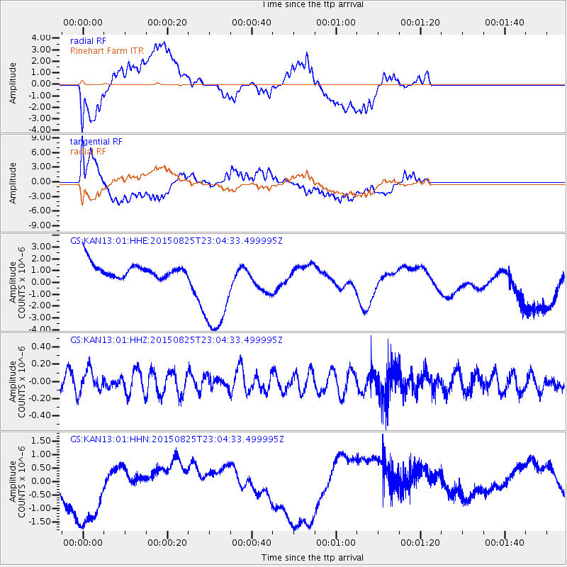
KAN13 Rinehart Farm - Earthquake Result Viewer
*The percent match for this event was below the threshold and hence no stack was calculated.
| Earthquake location: |
Kyushu, Japan |
| Earthquake latitude/longitude: |
32.1/131.8 |
| Earthquake time(UTC): |
2015/08/25 (237) 22:51:36 GMT |
| Earthquake Depth: |
44 km |
| Earthquake Magnitude: |
5.2 MW |
| Earthquake Catalog/Contributor: |
ISC/ISC |
|
| Network: |
GS US Geological Survey Networks |
| Station: |
KAN13 Rinehart Farm |
| Lat/Lon: |
37.01 N/97.48 W |
| Elevation: |
340 m |
|
| Distance: |
97.3 deg |
| Az: |
37.672 deg |
| Baz: |
319.591 deg |
| Ray Param: |
$rayparam |
*The percent match for this event was below the threshold and hence was not used in the summary stack. |
|
| Radial Match: |
44.84941 % |
| Radial Bump: |
400 |
| Transverse Match: |
54.13284 % |
| Transverse Bump: |
400 |
| SOD ConfigId: |
7422571 |
| Insert Time: |
2019-04-20 14:08:52.260 +0000 |
| GWidth: |
2.5 |
| Max Bumps: |
400 |
| Tol: |
0.001 |
|
Signal To Noise
| Channel | StoN | STA | LTA |
| GS:KAN13:01:HHZ:20150825T23:04:33.499995Z | 1.9280437 | 1.2578364E-7 | 6.5239E-8 |
| GS:KAN13:01:HHN:20150825T23:04:33.499995Z | 5.255908 | 1.6973748E-6 | 3.2294608E-7 |
| GS:KAN13:01:HHE:20150825T23:04:33.499995Z | 7.095635 | 4.257846E-6 | 6.0006556E-7 |
| Arrivals |
| Ps | |
| PpPs | |
| PsPs/PpSs | |


