You are here: Home > Network List > IU - Global Seismograph Network (GSN - IRIS/USGS) Stations List
> Station PMG Port Moresby, New Guinea > Earthquake Result Viewer
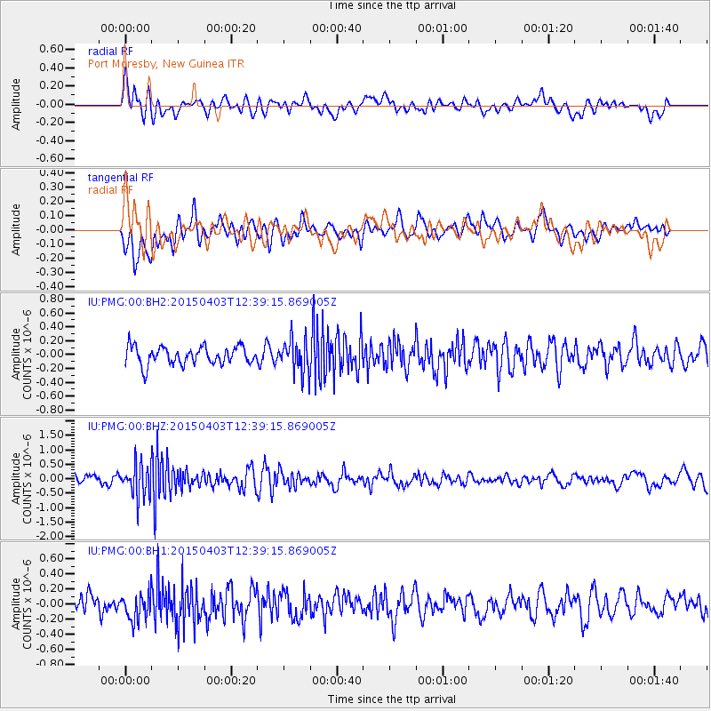
PMG Port Moresby, New Guinea - Earthquake Result Viewer
*The percent match for this event was below the threshold and hence no stack was calculated.
| Earthquake location: |
South Of Fiji Islands |
| Earthquake latitude/longitude: |
-23.0/-176.3 |
| Earthquake time(UTC): |
2015/04/03 (093) 12:32:38 GMT |
| Earthquake Depth: |
59 km |
| Earthquake Magnitude: |
5.5 MWC, 5.5 MWC |
| Earthquake Catalog/Contributor: |
NEIC PDE/NEIC COMCAT |
|
| Network: |
IU Global Seismograph Network (GSN - IRIS/USGS) |
| Station: |
PMG Port Moresby, New Guinea |
| Lat/Lon: |
9.40 S/147.16 E |
| Elevation: |
90 m |
|
| Distance: |
37.4 deg |
| Az: |
285.143 deg |
| Baz: |
115.67 deg |
| Ray Param: |
$rayparam |
*The percent match for this event was below the threshold and hence was not used in the summary stack. |
|
| Radial Match: |
61.33177 % |
| Radial Bump: |
400 |
| Transverse Match: |
56.436153 % |
| Transverse Bump: |
400 |
| SOD ConfigId: |
872571 |
| Insert Time: |
2015-05-14 09:43:30.629 +0000 |
| GWidth: |
2.5 |
| Max Bumps: |
400 |
| Tol: |
0.001 |
|
Signal To Noise
| Channel | StoN | STA | LTA |
| IU:PMG:00:BHZ:20150403T12:39:15.869005Z | 4.2288833 | 5.5241657E-7 | 1.3062942E-7 |
| IU:PMG:00:BH1:20150403T12:39:15.869005Z | 1.7230374 | 1.8320902E-7 | 1.0632911E-7 |
| IU:PMG:00:BH2:20150403T12:39:15.869005Z | 1.8575143 | 2.3510911E-7 | 1.265719E-7 |
| Arrivals |
| Ps | |
| PpPs | |
| PsPs/PpSs | |


