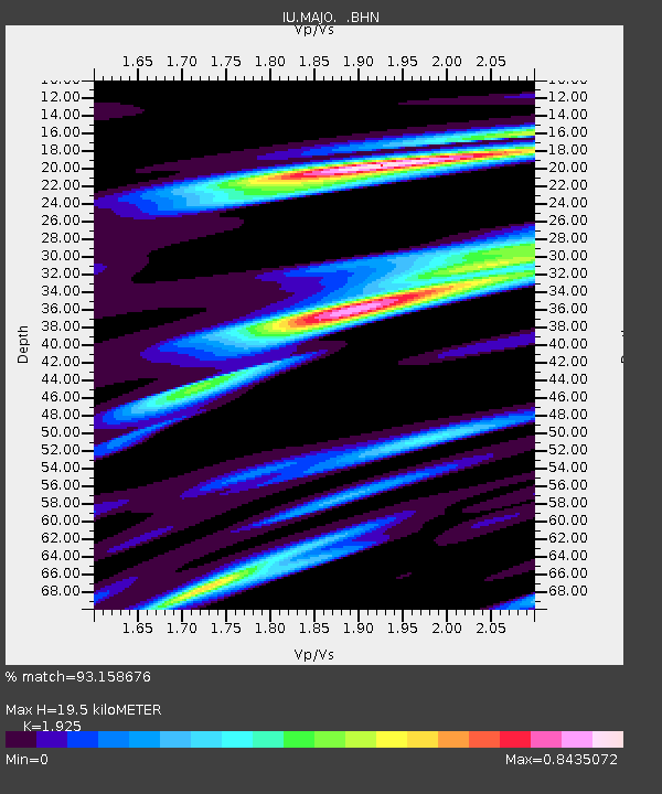
MAJO Matsushiro, Japan - Earthquake Result Viewer

Earthquake location: Minahassa Peninsula, Sulawesi
Earthquake latitude/longitude: 0.2/119.6
Earthquake time(UTC): 1998/05/21 (141) 05:34:25 GMT
Earthquake Depth: 33 km
Earthquake Magnitude: 6.2 MB, 6.3 MS, 6.6 UNKNOWN, 6.6 MW
Earthquake Catalog/Contributor: WHDF/NEIC
Network: IU Global Seismograph Network (GSN - IRIS/USGS)
Station: MAJO Matsushiro, Japan
Lat/Lon: 36.54 N/138.21 E
Elevation: 405 m
Distance: 40.1 deg
Az: 23.549 deg
Baz: 209.743 deg
Ray Param: 0.07454237
Estimated Moho Depth: 19.5 km
Estimated Crust Vp/Vs: 1.92
Assumed Crust Vp: 6.461 km/s
Estimated Crust Vs: 3.357 km/s
Estimated Crust Poisson's Ratio: 0.32
Radial Match: 93.158676 %
Radial Bump: 284
Transverse Match: 81.986725 %
Transverse Bump: 400
SOD ConfigId: 4480
Insert Time: 2010-03-04 16:06:54.771 +0000
GWidth: 2.5
Max Bumps: 400
Tol: 0.001

Signal To Noise

ChannelStoNSTALTA
IU:MAJO: :BHN:19980521T05:41:27.260986Z142.411547.850148E-65.5122978E-8
IU:MAJO: :BHE:19980521T05:41:27.260986Z80.862764.056959E-65.017092E-8
IU:MAJO: :BHZ:19980521T05:41:27.260986Z50.850542.2047573E-64.33576E-8
Arrivals
Ps3.0 SECOND
PpPs8.3 SECOND
PsPs/PpSs11 SECOND