You are here: Home > Network List > TA - USArray Transportable Network (new EarthScope stations) Stations List
> Station J01E Myrtle Point, OR, USA > Earthquake Result Viewer
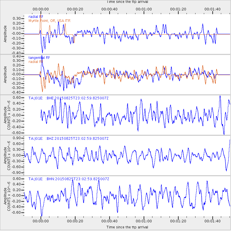
J01E Myrtle Point, OR, USA - Earthquake Result Viewer
*The percent match for this event was below the threshold and hence no stack was calculated.
| Earthquake location: |
Kyushu, Japan |
| Earthquake latitude/longitude: |
32.1/131.8 |
| Earthquake time(UTC): |
2015/08/25 (237) 22:51:36 GMT |
| Earthquake Depth: |
44 km |
| Earthquake Magnitude: |
5.2 MW |
| Earthquake Catalog/Contributor: |
ISC/ISC |
|
| Network: |
TA USArray Transportable Network (new EarthScope stations) |
| Station: |
J01E Myrtle Point, OR, USA |
| Lat/Lon: |
43.16 N/123.93 W |
| Elevation: |
128 m |
|
| Distance: |
78.1 deg |
| Az: |
46.436 deg |
| Baz: |
302.778 deg |
| Ray Param: |
$rayparam |
*The percent match for this event was below the threshold and hence was not used in the summary stack. |
|
| Radial Match: |
48.823067 % |
| Radial Bump: |
400 |
| Transverse Match: |
39.30834 % |
| Transverse Bump: |
400 |
| SOD ConfigId: |
7422571 |
| Insert Time: |
2019-04-20 14:11:13.469 +0000 |
| GWidth: |
2.5 |
| Max Bumps: |
400 |
| Tol: |
0.001 |
|
Signal To Noise
| Channel | StoN | STA | LTA |
| TA:J01E: :BHZ:20150825T23:02:59.825007Z | 0.974617 | 2.1639937E-7 | 2.220353E-7 |
| TA:J01E: :BHN:20150825T23:02:59.825007Z | 1.5339328 | 3.95293E-7 | 2.5769904E-7 |
| TA:J01E: :BHE:20150825T23:02:59.825007Z | 1.1701897 | 2.563353E-7 | 2.1905448E-7 |
| Arrivals |
| Ps | |
| PpPs | |
| PsPs/PpSs | |


