You are here: Home > Network List > IU - Global Seismograph Network (GSN - IRIS/USGS) Stations List
> Station MAJO Matsushiro, Japan > Earthquake Result Viewer
MAJO Matsushiro, Japan - Earthquake Result Viewer
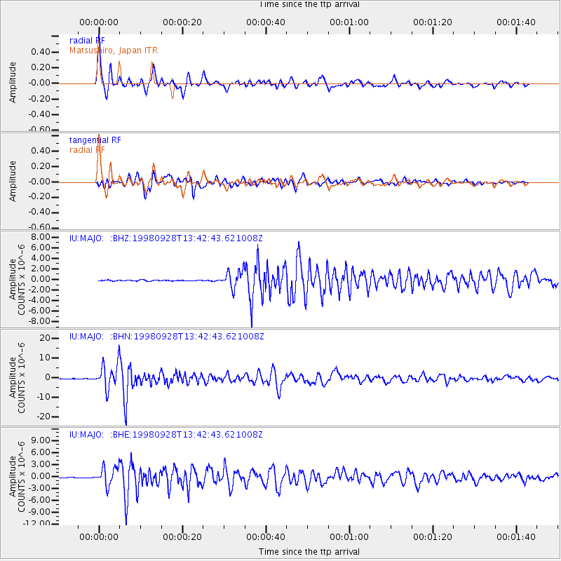
| Earthquake location: |
Java, Indonesia |
| Earthquake latitude/longitude: |
-8.2/112.4 |
| Earthquake time(UTC): |
1998/09/28 (271) 13:34:30 GMT |
| Earthquake Depth: |
152 km |
| Earthquake Magnitude: |
6.4 MB, 6.5 UNKNOWN, 6.5 MW |
| Earthquake Catalog/Contributor: |
WHDF/NEIC |
|
| Network: |
IU Global Seismograph Network (GSN - IRIS/USGS) |
| Station: |
MAJO Matsushiro, Japan |
| Lat/Lon: |
36.54 N/138.21 E |
| Elevation: |
405 m |
|
| Distance: |
50.7 deg |
| Az: |
26.94 deg |
| Baz: |
213.843 deg |
| Ray Param: |
0.06739066 |
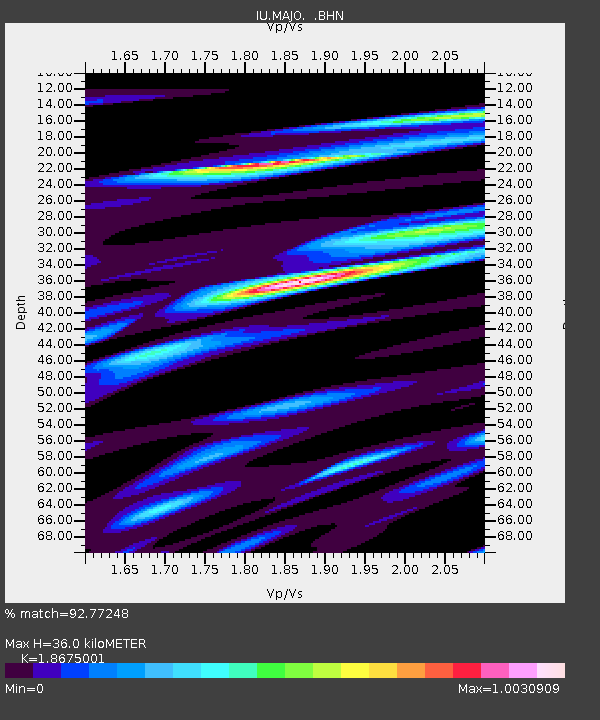
| Estimated Moho Depth: |
36.0 km |
| Estimated Crust Vp/Vs: |
1.87 |
| Assumed Crust Vp: |
6.461 km/s |
| Estimated Crust Vs: |
3.46 km/s |
| Estimated Crust Poisson's Ratio: |
0.30 |
|
| Radial Match: |
92.77248 % |
| Radial Bump: |
366 |
| Transverse Match: |
89.694954 % |
| Transverse Bump: |
400 |
| SOD ConfigId: |
4480 |
| Insert Time: |
2010-03-04 16:07:16.505 +0000 |
| GWidth: |
2.5 |
| Max Bumps: |
400 |
| Tol: |
0.001 |
|
Signal To Noise
| Channel | StoN | STA | LTA |
| IU:MAJO: :BHN:19980928T13:42:43.621008Z | 71.15256 | 6.4031333E-6 | 8.9991616E-8 |
| IU:MAJO: :BHE:19980928T13:42:43.621008Z | 35.13429 | 2.3090283E-6 | 6.572008E-8 |
| IU:MAJO: :BHZ:19980928T13:42:43.621008Z | 20.853468 | 1.6390333E-6 | 7.859763E-8 |
| Arrivals |
| Ps | 5.1 SECOND |
| PpPs | 15 SECOND |
| PsPs/PpSs | 20 SECOND |


