You are here: Home > Network List > IU - Global Seismograph Network (GSN - IRIS/USGS) Stations List
> Station MAJO Matsushiro, Japan > Earthquake Result Viewer
MAJO Matsushiro, Japan - Earthquake Result Viewer

| Earthquake location: |
Santa Cruz Islands |
| Earthquake latitude/longitude: |
-12.6/166.4 |
| Earthquake time(UTC): |
2002/06/17 (168) 21:26:22 GMT |
| Earthquake Depth: |
33 km |
| Earthquake Magnitude: |
6.0 MB, 6.7 MS, 6.7 MW, 6.6 MW |
| Earthquake Catalog/Contributor: |
WHDF/NEIC |
|
| Network: |
IU Global Seismograph Network (GSN - IRIS/USGS) |
| Station: |
MAJO Matsushiro, Japan |
| Lat/Lon: |
36.54 N/138.21 E |
| Elevation: |
405 m |
|
| Distance: |
55.6 deg |
| Az: |
332.566 deg |
| Baz: |
146.047 deg |
| Ray Param: |
0.06461274 |
| Estimated Moho Depth: |
33.5 km |
| Estimated Crust Vp/Vs: |
1.76 |
| Assumed Crust Vp: |
6.461 km/s |
| Estimated Crust Vs: |
3.676 km/s |
| Estimated Crust Poisson's Ratio: |
0.26 |
|
| Radial Match: |
91.36722 % |
| Radial Bump: |
400 |
| Transverse Match: |
76.28384 % |
| Transverse Bump: |
400 |
| SOD ConfigId: |
20082 |
| Insert Time: |
2010-03-04 16:07:32.384 +0000 |
| GWidth: |
2.5 |
| Max Bumps: |
400 |
| Tol: |
0.001 |
|
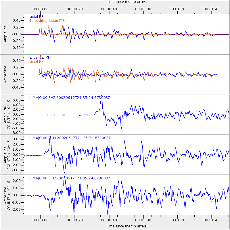
Signal To Noise
| Channel | StoN | STA | LTA |
| IU:MAJO:00:BHN:20020617T21:35:24.873003Z | 8.739231 | 5.433627E-7 | 6.217511E-8 |
| IU:MAJO:00:BHE:20020617T21:35:24.873003Z | 6.0516644 | 3.1608243E-7 | 5.223066E-8 |
| IU:MAJO:00:BHZ:20020617T21:35:24.873003Z | 28.46321 | 1.29517E-6 | 4.5503302E-8 |
| Arrivals |
| Ps | 4.1 SECOND |
| PpPs | 14 SECOND |
| PsPs/PpSs | 18 SECOND |


