You are here: Home > Network List > IU - Global Seismograph Network (GSN - IRIS/USGS) Stations List
> Station MAJO Matsushiro, Japan > Earthquake Result Viewer
MAJO Matsushiro, Japan - Earthquake Result Viewer

| Earthquake location: |
Halmahera, Indonesia |
| Earthquake latitude/longitude: |
1.8/127.2 |
| Earthquake time(UTC): |
2002/05/26 (146) 00:10:21 GMT |
| Earthquake Depth: |
109 km |
| Earthquake Magnitude: |
5.8 MB, 5.9 MW, 5.8 MW |
| Earthquake Catalog/Contributor: |
WHDF/NEIC |
|
| Network: |
IU Global Seismograph Network (GSN - IRIS/USGS) |
| Station: |
MAJO Matsushiro, Japan |
| Lat/Lon: |
36.54 N/138.21 E |
| Elevation: |
405 m |
|
| Distance: |
36.0 deg |
| Az: |
15.113 deg |
| Baz: |
198.88 deg |
| Ray Param: |
0.076561205 |
| Estimated Moho Depth: |
35.0 km |
| Estimated Crust Vp/Vs: |
1.90 |
| Assumed Crust Vp: |
6.461 km/s |
| Estimated Crust Vs: |
3.396 km/s |
| Estimated Crust Poisson's Ratio: |
0.31 |
|
| Radial Match: |
90.59995 % |
| Radial Bump: |
365 |
| Transverse Match: |
80.92104 % |
| Transverse Bump: |
400 |
| SOD ConfigId: |
20082 |
| Insert Time: |
2010-03-04 16:07:38.415 +0000 |
| GWidth: |
2.5 |
| Max Bumps: |
400 |
| Tol: |
0.001 |
|
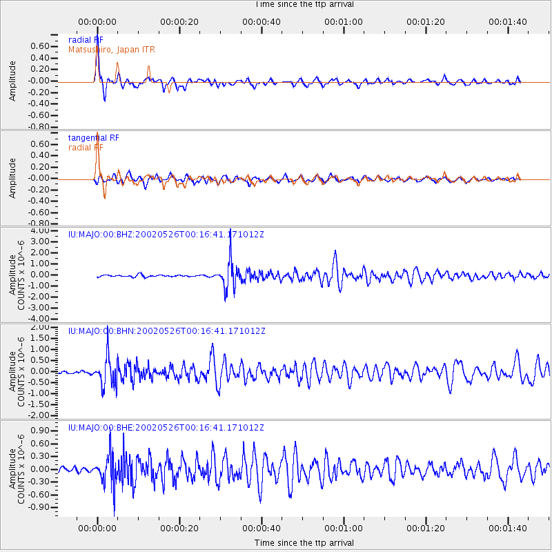
Signal To Noise
| Channel | StoN | STA | LTA |
| IU:MAJO:00:BHN:20020526T00:16:41.171012Z | 12.562019 | 6.6065985E-7 | 5.259185E-8 |
| IU:MAJO:00:BHE:20020526T00:16:41.171012Z | 6.2001657 | 3.490821E-7 | 5.6302056E-8 |
| IU:MAJO:00:BHZ:20020526T00:16:41.171012Z | 14.721837 | 1.2643203E-6 | 8.58806E-8 |
| Arrivals |
| Ps | 5.2 SECOND |
| PpPs | 15 SECOND |
| PsPs/PpSs | 20 SECOND |


