You are here: Home > Network List > IU - Global Seismograph Network (GSN - IRIS/USGS) Stations List
> Station MAJO Matsushiro, Japan > Earthquake Result Viewer
MAJO Matsushiro, Japan - Earthquake Result Viewer
| Earthquake location: |
Banda Sea |
| Earthquake latitude/longitude: |
-6.9/128.9 |
| Earthquake time(UTC): |
2001/11/20 (324) 21:08:18 GMT |
| Earthquake Depth: |
33 km |
| Earthquake Magnitude: |
5.7 MB, 6.0 MS, 6.3 MW, 6.2 MW |
| Earthquake Catalog/Contributor: |
WHDF/NEIC |
|
| Network: |
IU Global Seismograph Network (GSN - IRIS/USGS) |
| Station: |
MAJO Matsushiro, Japan |
| Lat/Lon: |
36.54 N/138.21 E |
| Elevation: |
405 m |
|
| Distance: |
44.1 deg |
| Az: |
10.77 deg |
| Baz: |
193.32 deg |
| Ray Param: |
0.072083116 |
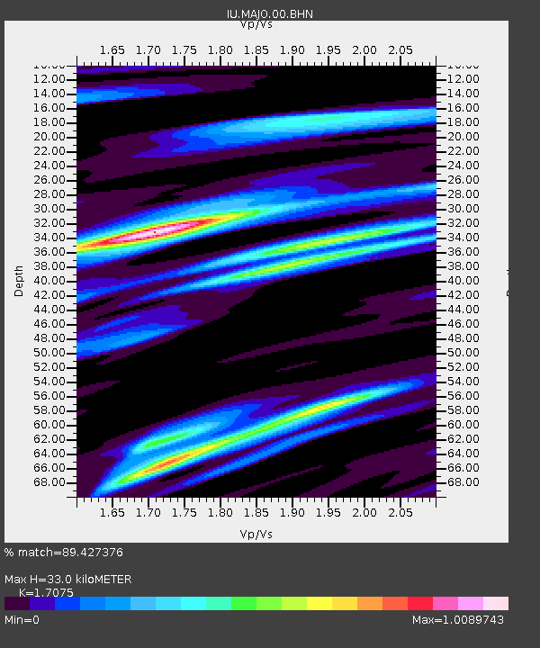
| Estimated Moho Depth: |
33.0 km |
| Estimated Crust Vp/Vs: |
1.71 |
| Assumed Crust Vp: |
6.461 km/s |
| Estimated Crust Vs: |
3.784 km/s |
| Estimated Crust Poisson's Ratio: |
0.24 |
|
| Radial Match: |
89.427376 % |
| Radial Bump: |
400 |
| Transverse Match: |
80.44747 % |
| Transverse Bump: |
400 |
| SOD ConfigId: |
20082 |
| Insert Time: |
2010-03-04 16:07:49.031 +0000 |
| GWidth: |
2.5 |
| Max Bumps: |
400 |
| Tol: |
0.001 |
|
Signal To Noise
| Channel | StoN | STA | LTA |
| IU:MAJO:00:BHN:20011120T21:15:52.686012Z | 3.0008478 | 1.566814E-7 | 5.221238E-8 |
| IU:MAJO:00:BHE:20011120T21:15:52.686012Z | 1.4688896 | 8.7785956E-8 | 5.976349E-8 |
| IU:MAJO:00:BHZ:20011120T21:15:52.686012Z | 3.2532904 | 2.7213295E-7 | 8.364852E-8 |
| Arrivals |
| Ps | 3.9 SECOND |
| PpPs | 13 SECOND |
| PsPs/PpSs | 17 SECOND |


