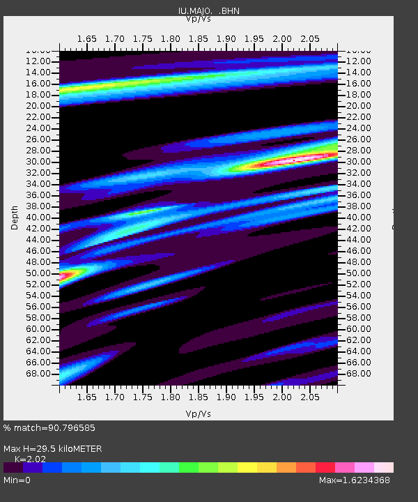
MAJO Matsushiro, Japan - Earthquake Result Viewer

Earthquake location: New Ireland Region, P.N.G.
Earthquake latitude/longitude: -4.6/153.2
Earthquake time(UTC): 1999/01/19 (019) 03:35:33 GMT
Earthquake Depth: 114 km
Earthquake Magnitude: 5.8 MB, 6.4 MS, 7.0 MW, 6.5 ME
Earthquake Catalog/Contributor: WHDF/NEIC
Network: IU Global Seismograph Network (GSN - IRIS/USGS)
Station: MAJO Matsushiro, Japan
Lat/Lon: 36.54 N/138.21 E
Elevation: 405 m
Distance: 43.3 deg
Az: 342.264 deg
Baz: 157.847 deg
Ray Param: 0.072246134
Estimated Moho Depth: 29.5 km
Estimated Crust Vp/Vs: 2.02
Assumed Crust Vp: 6.461 km/s
Estimated Crust Vs: 3.199 km/s
Estimated Crust Poisson's Ratio: 0.34
Radial Match: 90.796585 %
Radial Bump: 400
Transverse Match: 82.96169 %
Transverse Bump: 400
SOD ConfigId: 4480
Insert Time: 2010-03-04 16:08:08.295 +0000
GWidth: 2.5
Max Bumps: 400
Tol: 0.001

Signal To Noise

ChannelStoNSTALTA
IU:MAJO: :BHN:19990119T03:42:53.665012Z3.52970936.936777E-71.9652545E-7
IU:MAJO: :BHE:19990119T03:42:53.665012Z2.85946184.6288704E-71.6187909E-7
IU:MAJO: :BHZ:19990119T03:42:53.665012Z1.68455761.976991E-71.17359654E-7
Arrivals
Ps4.9 SECOND
PpPs13 SECOND
PsPs/PpSs18 SECOND