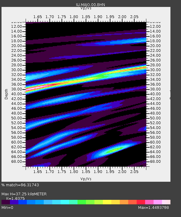
MAJO Matsushiro, Japan - Earthquake Result Viewer

Earthquake location: Northern Sumatra, Indonesia
Earthquake latitude/longitude: 2.4/96.3
Earthquake time(UTC): 2006/08/11 (223) 20:54:14 GMT
Earthquake Depth: 22 km
Earthquake Magnitude: 5.8 MB, 6.2 MS, 6.2 MW, 6.1 MW
Earthquake Catalog/Contributor: WHDF/NEIC
Network: IU Global Seismograph Network (GSN - IRIS/USGS)
Station: MAJO Matsushiro, Japan
Lat/Lon: 36.54 N/138.21 E
Elevation: 405 m
Distance: 51.4 deg
Az: 43.447 deg
Baz: 238.56 deg
Ray Param: 0.06741271
Estimated Moho Depth: 37.25 km
Estimated Crust Vp/Vs: 1.64
Assumed Crust Vp: 6.461 km/s
Estimated Crust Vs: 3.946 km/s
Estimated Crust Poisson's Ratio: 0.20
Radial Match: 96.31743 %
Radial Bump: 400
Transverse Match: 83.765015 %
Transverse Bump: 400
SOD ConfigId: 2564
Insert Time: 2010-03-04 16:08:32.659 +0000
GWidth: 2.5
Max Bumps: 400
Tol: 0.001

Signal To Noise

ChannelStoNSTALTA
IU:MAJO:00:BHN:20060811T21:02:46.573003Z4.75069147.814655E-71.644951E-7
IU:MAJO:00:BHE:20060811T21:02:46.573003Z11.2079791.2731456E-61.1359278E-7
IU:MAJO:00:BHZ:20060811T21:02:46.573003Z34.0006453.1265185E-69.195468E-8
Arrivals
Ps3.9 SECOND
PpPs14 SECOND
PsPs/PpSs18 SECOND