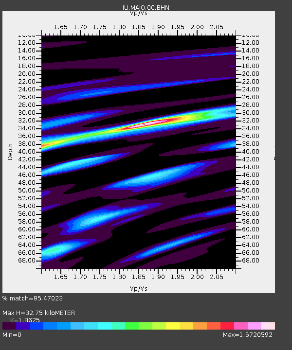
MAJO Matsushiro, Japan - Earthquake Result Viewer

Earthquake location: Northern Sumatra, Indonesia
Earthquake latitude/longitude: 1.7/97.1
Earthquake time(UTC): 2006/07/27 (208) 11:16:40 GMT
Earthquake Depth: 20 km
Earthquake Magnitude: 5.6 MB, 6.1 MS, 6.1 MW, 6.0 MW
Earthquake Catalog/Contributor: WHDF/NEIC
Network: IU Global Seismograph Network (GSN - IRIS/USGS)
Station: MAJO Matsushiro, Japan
Lat/Lon: 36.54 N/138.21 E
Elevation: 405 m
Distance: 51.4 deg
Az: 42.633 deg
Baz: 237.21 deg
Ray Param: 0.06744253
Estimated Moho Depth: 32.75 km
Estimated Crust Vp/Vs: 1.86
Assumed Crust Vp: 6.461 km/s
Estimated Crust Vs: 3.469 km/s
Estimated Crust Poisson's Ratio: 0.30
Radial Match: 95.47023 %
Radial Bump: 378
Transverse Match: 88.054825 %
Transverse Bump: 400
SOD ConfigId: 2665
Insert Time: 2010-03-04 16:08:50.467 +0000
GWidth: 2.5
Max Bumps: 400
Tol: 0.001

Signal To Noise

ChannelStoNSTALTA
IU:MAJO:00:BHN:20060727T11:25:12.547002Z13.9189958.296942E-75.960877E-8
IU:MAJO:00:BHE:20060727T11:25:12.547002Z19.012461.0747947E-65.6531064E-8
IU:MAJO:00:BHZ:20060727T11:25:12.547002Z34.492852.6843645E-67.782379E-8
Arrivals
Ps4.6 SECOND
PpPs14 SECOND
PsPs/PpSs18 SECOND