You are here: Home > Network List > IU - Global Seismograph Network (GSN - IRIS/USGS) Stations List
> Station MAJO Matsushiro, Japan > Earthquake Result Viewer
MAJO Matsushiro, Japan - Earthquake Result Viewer
| Earthquake location: |
Banda Sea |
| Earthquake latitude/longitude: |
-4.7/126.8 |
| Earthquake time(UTC): |
2006/05/22 (142) 20:53:57 GMT |
| Earthquake Depth: |
2.8 km |
| Earthquake Magnitude: |
5.8 MB, 5.9 MS, 6.1 MW, 6.1 MW |
| Earthquake Catalog/Contributor: |
WHDF/NEIC |
|
| Network: |
IU Global Seismograph Network (GSN - IRIS/USGS) |
| Station: |
MAJO Matsushiro, Japan |
| Lat/Lon: |
36.54 N/138.21 E |
| Elevation: |
405 m |
|
| Distance: |
42.4 deg |
| Az: |
13.649 deg |
| Baz: |
196.98 deg |
| Ray Param: |
0.07321144 |
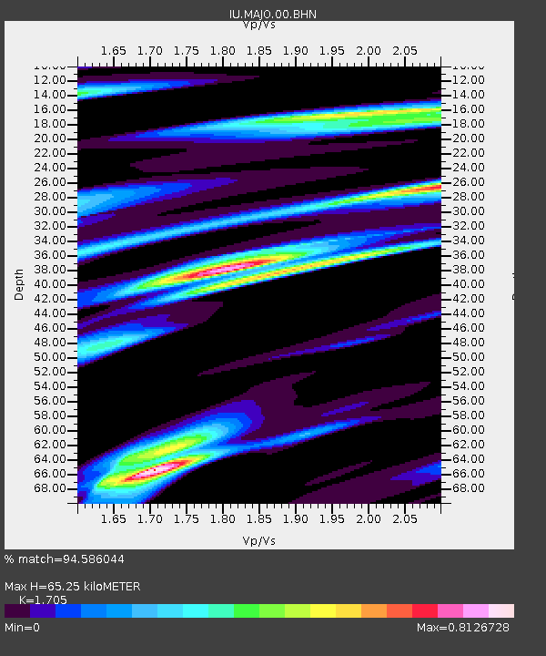
| Estimated Moho Depth: |
65.25 km |
| Estimated Crust Vp/Vs: |
1.71 |
| Assumed Crust Vp: |
6.461 km/s |
| Estimated Crust Vs: |
3.79 km/s |
| Estimated Crust Poisson's Ratio: |
0.24 |
|
| Radial Match: |
94.586044 % |
| Radial Bump: |
276 |
| Transverse Match: |
92.26457 % |
| Transverse Bump: |
400 |
| SOD ConfigId: |
2669 |
| Insert Time: |
2010-03-04 16:08:57.670 +0000 |
| GWidth: |
2.5 |
| Max Bumps: |
400 |
| Tol: |
0.001 |
|

Signal To Noise
| Channel | StoN | STA | LTA |
| IU:MAJO:00:BHN:20060522T21:01:22.248013Z | 4.1190376 | 2.437145E-7 | 5.9167828E-8 |
| IU:MAJO:00:BHE:20060522T21:01:22.248013Z | 1.8759462 | 1.03490116E-7 | 5.516689E-8 |
| IU:MAJO:00:BHZ:20060522T21:01:22.248013Z | 5.946198 | 3.8128059E-7 | 6.412174E-8 |
| Arrivals |
| Ps | 7.6 SECOND |
| PpPs | 25 SECOND |
| PsPs/PpSs | 33 SECOND |


