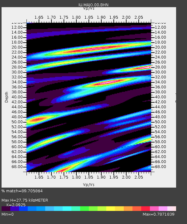
MAJO Matsushiro, Japan - Earthquake Result Viewer

Earthquake location: Fox Islands, Aleutian Islands
Earthquake latitude/longitude: 52.5/-169.3
Earthquake time(UTC): 2006/05/10 (130) 02:42:51 GMT
Earthquake Depth: 18 km
Earthquake Magnitude: 6.1 MB, 6.2 MS, 6.4 MW, 6.3 MW
Earthquake Catalog/Contributor: WHDF/NEIC
Network: IU Global Seismograph Network (GSN - IRIS/USGS)
Station: MAJO Matsushiro, Japan
Lat/Lon: 36.54 N/138.21 E
Elevation: 405 m
Distance: 39.8 deg
Az: 267.722 deg
Baz: 49.311 deg
Ray Param: 0.074769616
Estimated Moho Depth: 27.75 km
Estimated Crust Vp/Vs: 2.09
Assumed Crust Vp: 6.461 km/s
Estimated Crust Vs: 3.088 km/s
Estimated Crust Poisson's Ratio: 0.35
Radial Match: 89.705864 %
Radial Bump: 400
Transverse Match: 79.15146 %
Transverse Bump: 400
SOD ConfigId: 2669
Insert Time: 2010-03-04 16:08:58.981 +0000
GWidth: 2.5
Max Bumps: 400
Tol: 0.001

Signal To Noise

ChannelStoNSTALTA
IU:MAJO:00:BHN:20060510T02:49:51.945985Z8.7807478.852214E-71.008139E-7
IU:MAJO:00:BHE:20060510T02:49:51.945985Z11.5494218.3127355E-77.197534E-8
IU:MAJO:00:BHZ:20060510T02:49:51.945985Z27.4589122.48153E-69.0372474E-8
Arrivals
Ps5.0 SECOND
PpPs13 SECOND
PsPs/PpSs17 SECOND