You are here: Home > Network List > TA - USArray Transportable Network (new EarthScope stations) Stations List
> Station O03E Paynes Creek, CA, USA > Earthquake Result Viewer
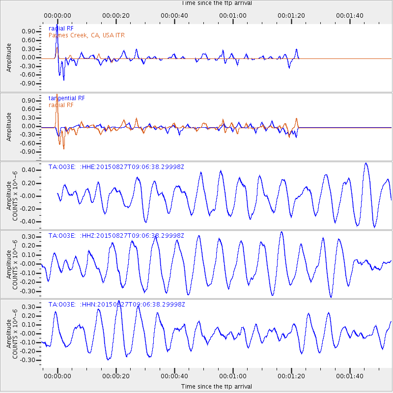
O03E Paynes Creek, CA, USA - Earthquake Result Viewer
*The percent match for this event was below the threshold and hence no stack was calculated.
| Earthquake location: |
W. Caroline Islands, Micronesia |
| Earthquake latitude/longitude: |
12.0/140.4 |
| Earthquake time(UTC): |
2015/08/27 (239) 08:54:21 GMT |
| Earthquake Depth: |
30 km |
| Earthquake Magnitude: |
4.8 mb |
| Earthquake Catalog/Contributor: |
ISC/ISC |
|
| Network: |
TA USArray Transportable Network (new EarthScope stations) |
| Station: |
O03E Paynes Creek, CA, USA |
| Lat/Lon: |
40.29 N/121.80 W |
| Elevation: |
967 m |
|
| Distance: |
88.2 deg |
| Az: |
49.3 deg |
| Baz: |
284.139 deg |
| Ray Param: |
$rayparam |
*The percent match for this event was below the threshold and hence was not used in the summary stack. |
|
| Radial Match: |
65.42625 % |
| Radial Bump: |
400 |
| Transverse Match: |
31.2719 % |
| Transverse Bump: |
400 |
| SOD ConfigId: |
7422571 |
| Insert Time: |
2019-04-20 14:35:46.819 +0000 |
| GWidth: |
2.5 |
| Max Bumps: |
400 |
| Tol: |
0.001 |
|
Signal To Noise
| Channel | StoN | STA | LTA |
| TA:O03E: :HHZ:20150827T09:06:38.29998Z | 0.43248245 | 5.9304597E-8 | 1.3712601E-7 |
| TA:O03E: :HHN:20150827T09:06:38.29998Z | 1.2411019 | 1.3308643E-7 | 1.07232474E-7 |
| TA:O03E: :HHE:20150827T09:06:38.29998Z | 2.066539 | 2.2941283E-7 | 1.11013065E-7 |
| Arrivals |
| Ps | |
| PpPs | |
| PsPs/PpSs | |


