You are here: Home > Network List > TA - USArray Transportable Network (new EarthScope stations) Stations List
> Station R11A Troy Canyon, Currant, NV, USA > Earthquake Result Viewer
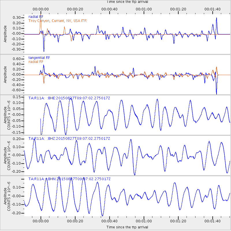
R11A Troy Canyon, Currant, NV, USA - Earthquake Result Viewer
*The percent match for this event was below the threshold and hence no stack was calculated.
| Earthquake location: |
W. Caroline Islands, Micronesia |
| Earthquake latitude/longitude: |
12.0/140.4 |
| Earthquake time(UTC): |
2015/08/27 (239) 08:54:21 GMT |
| Earthquake Depth: |
30 km |
| Earthquake Magnitude: |
4.8 mb |
| Earthquake Catalog/Contributor: |
ISC/ISC |
|
| Network: |
TA USArray Transportable Network (new EarthScope stations) |
| Station: |
R11A Troy Canyon, Currant, NV, USA |
| Lat/Lon: |
38.35 N/115.59 W |
| Elevation: |
1756 m |
|
| Distance: |
93.4 deg |
| Az: |
49.828 deg |
| Baz: |
288.059 deg |
| Ray Param: |
$rayparam |
*The percent match for this event was below the threshold and hence was not used in the summary stack. |
|
| Radial Match: |
55.414272 % |
| Radial Bump: |
400 |
| Transverse Match: |
53.81295 % |
| Transverse Bump: |
332 |
| SOD ConfigId: |
7422571 |
| Insert Time: |
2019-04-20 14:35:48.702 +0000 |
| GWidth: |
2.5 |
| Max Bumps: |
400 |
| Tol: |
0.001 |
|
Signal To Noise
| Channel | StoN | STA | LTA |
| TA:R11A: :BHZ:20150827T09:07:02.275017Z | 0.6591864 | 5.0278928E-8 | 7.627421E-8 |
| TA:R11A: :BHN:20150827T09:07:02.275017Z | 2.0594568 | 1.3580612E-7 | 6.594269E-8 |
| TA:R11A: :BHE:20150827T09:07:02.275017Z | 0.8157246 | 7.70336E-8 | 9.443579E-8 |
| Arrivals |
| Ps | |
| PpPs | |
| PsPs/PpSs | |


