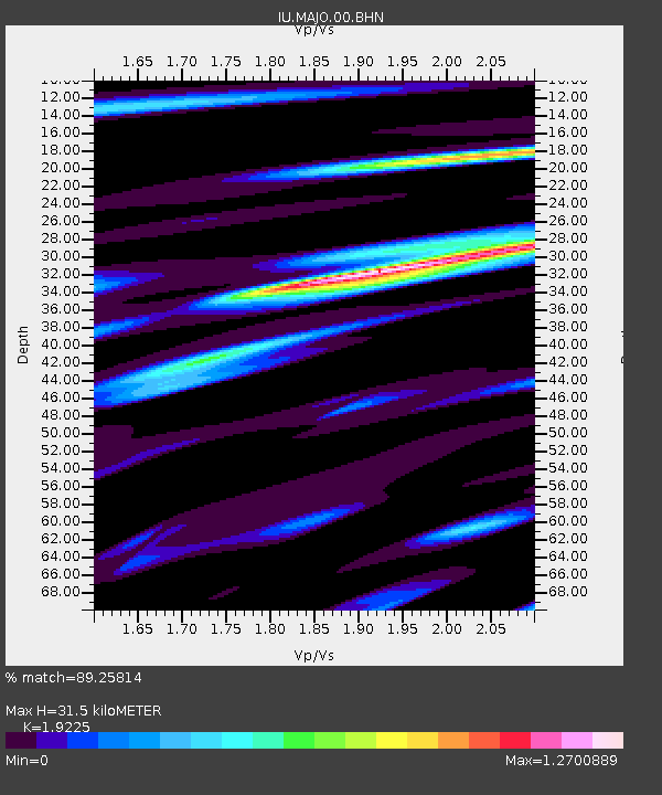
MAJO Matsushiro, Japan - Earthquake Result Viewer
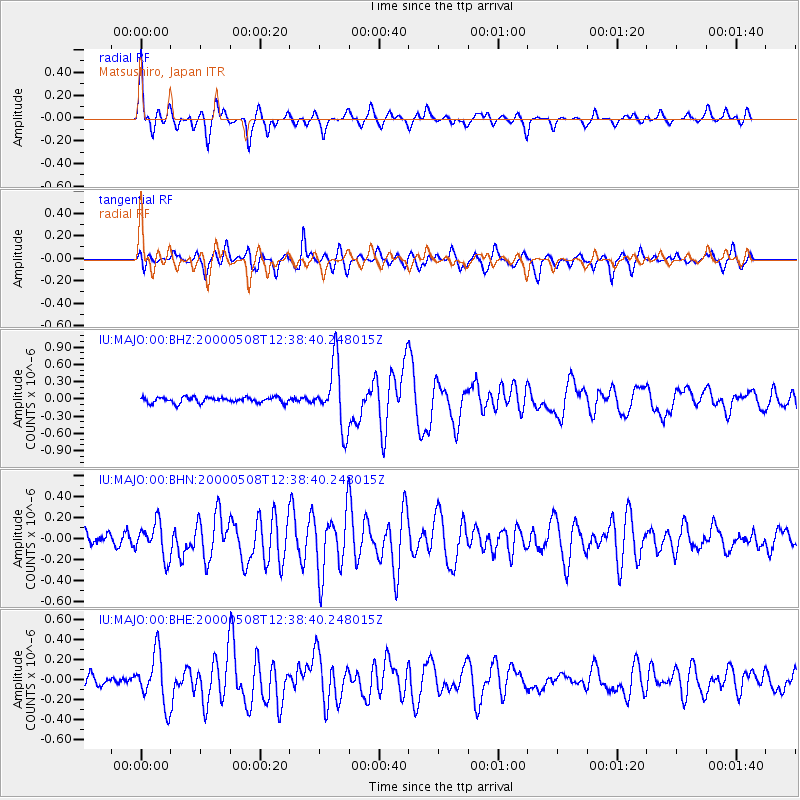
Earthquake location: Southwest Of Sumatra, Indonesia
Earthquake latitude/longitude: -0.8/98.0
Earthquake time(UTC): 2000/05/08 (129) 12:29:59 GMT
Earthquake Depth: 33 km
Earthquake Magnitude: 5.6 MB, 5.3 MS, 5.9 MW, 5.6 MW
Earthquake Catalog/Contributor: WHDF/NEIC
Network: IU Global Seismograph Network (GSN - IRIS/USGS)
Station: MAJO Matsushiro, Japan
Lat/Lon: 36.54 N/138.21 E
Elevation: 405 m
Distance: 52.7 deg
Az: 40.826 deg
Baz: 234.263 deg
Ray Param: 0.06654298
Estimated Moho Depth: 31.5 km
Estimated Crust Vp/Vs: 1.92
Assumed Crust Vp: 6.461 km/s
Estimated Crust Vs: 3.361 km/s
Estimated Crust Poisson's Ratio: 0.31
Radial Match: 89.25814 %
Radial Bump: 392
Transverse Match: 82.684296 %
Transverse Bump: 400
SOD ConfigId: 3753
Insert Time: 2010-03-04 16:09:17.525 +0000
GWidth: 2.5
Max Bumps: 400
Tol: 0.001

Signal To Noise

ChannelStoNSTALTA
IU:MAJO:00:BHN:20000508T12:38:40.248015Z2.972311.620366E-75.451538E-8
IU:MAJO:00:BHE:20000508T12:38:40.248015Z6.30902432.5521723E-74.0452726E-8
IU:MAJO:00:BHZ:20000508T12:38:40.248015Z11.1199295.560636E-75.0006033E-8
Arrivals
Ps4.7 SECOND
PpPs14 SECOND
PsPs/PpSs18 SECOND