You are here: Home > Network List > ZQ15 - Taku Glacier Stations List
> Station GAGA Taku Glacier, Alaska, USA > Earthquake Result Viewer
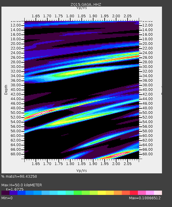
GAGA Taku Glacier, Alaska, USA - Earthquake Result Viewer
| Earthquake location: |
W. Caroline Islands, Micronesia |
| Earthquake latitude/longitude: |
12.0/140.4 |
| Earthquake time(UTC): |
2015/08/27 (239) 08:54:21 GMT |
| Earthquake Depth: |
30 km |
| Earthquake Magnitude: |
4.8 mb |
| Earthquake Catalog/Contributor: |
ISC/ISC |
|
| Network: |
ZQ Taku Glacier |
| Station: |
GAGA Taku Glacier, Alaska, USA |
| Lat/Lon: |
58.44 N/134.05 W |
| Elevation: |
258 m |
|
| Distance: |
77.5 deg |
| Az: |
32.482 deg |
| Baz: |
272.625 deg |
| Ray Param: |
0.050218068 |
| Estimated Moho Depth: |
50.0 km |
| Estimated Crust Vp/Vs: |
1.67 |
| Assumed Crust Vp: |
6.566 km/s |
| Estimated Crust Vs: |
3.926 km/s |
| Estimated Crust Poisson's Ratio: |
0.22 |
|
| Radial Match: |
98.43258 % |
| Radial Bump: |
111 |
| Transverse Match: |
53.79761 % |
| Transverse Bump: |
400 |
| SOD ConfigId: |
7422571 |
| Insert Time: |
2019-04-20 14:37:21.028 +0000 |
| GWidth: |
2.5 |
| Max Bumps: |
400 |
| Tol: |
0.001 |
|

Signal To Noise
| Channel | StoN | STA | LTA |
| ZQ:GAGA: :HHZ:20150827T09:05:43.30999Z | 0.920787 | 1.1876171E-7 | 1.2897848E-7 |
| ZQ:GAGA: :HH1:20150827T09:05:43.30999Z | 1.1502137 | 4.607483E-8 | 4.005763E-8 |
| ZQ:GAGA: :HH2:20150827T09:05:43.30999Z | 1.0165215 | 1.6305242E-7 | 1.6040235E-7 |
| Arrivals |
| Ps | 5.3 SECOND |
| PpPs | 20 SECOND |
| PsPs/PpSs | 25 SECOND |


