You are here: Home > Network List > IU - Global Seismograph Network (GSN - IRIS/USGS) Stations List
> Station MAJO Matsushiro, Japan > Earthquake Result Viewer
MAJO Matsushiro, Japan - Earthquake Result Viewer
| Earthquake location: |
Banda Sea |
| Earthquake latitude/longitude: |
-4.2/127.3 |
| Earthquake time(UTC): |
2000/08/28 (241) 19:29:24 GMT |
| Earthquake Depth: |
33 km |
| Earthquake Magnitude: |
6.0 MB |
| Earthquake Catalog/Contributor: |
WHDF/NEIC |
|
| Network: |
IU Global Seismograph Network (GSN - IRIS/USGS) |
| Station: |
MAJO Matsushiro, Japan |
| Lat/Lon: |
36.54 N/138.21 E |
| Elevation: |
405 m |
|
| Distance: |
41.8 deg |
| Az: |
13.214 deg |
| Baz: |
196.446 deg |
| Ray Param: |
0.07352267 |
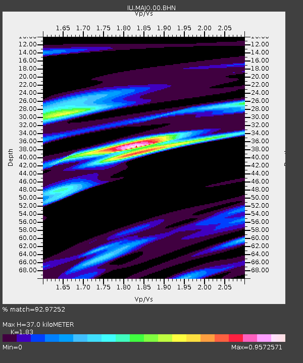
| Estimated Moho Depth: |
37.0 km |
| Estimated Crust Vp/Vs: |
1.83 |
| Assumed Crust Vp: |
6.461 km/s |
| Estimated Crust Vs: |
3.531 km/s |
| Estimated Crust Poisson's Ratio: |
0.29 |
|
| Radial Match: |
92.97252 % |
| Radial Bump: |
248 |
| Transverse Match: |
82.15081 % |
| Transverse Bump: |
377 |
| SOD ConfigId: |
3744 |
| Insert Time: |
2010-03-04 16:09:34.653 +0000 |
| GWidth: |
2.5 |
| Max Bumps: |
400 |
| Tol: |
0.001 |
|
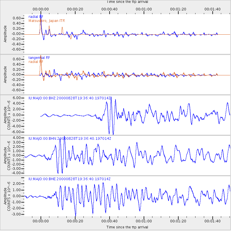
Signal To Noise
| Channel | StoN | STA | LTA |
| IU:MAJO:00:BHN:20000828T19:36:40.197014Z | 1.7343642 | 4.1161002E-7 | 2.3732618E-7 |
| IU:MAJO:00:BHE:20000828T19:36:40.197014Z | 1.240585 | 1.3875585E-7 | 1.11847115E-7 |
| IU:MAJO:00:BHZ:20000828T19:36:40.197014Z | 3.0538962 | 6.822251E-7 | 2.2339499E-7 |
| Arrivals |
| Ps | 5.1 SECOND |
| PpPs | 15 SECOND |
| PsPs/PpSs | 20 SECOND |


