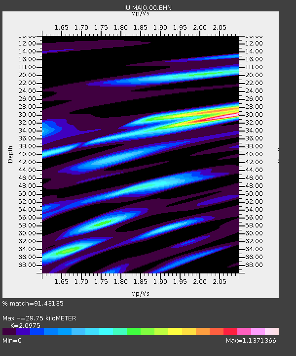
MAJO Matsushiro, Japan - Earthquake Result Viewer

Earthquake location: Southern Sumatra, Indonesia
Earthquake latitude/longitude: -4.7/102.1
Earthquake time(UTC): 2000/06/04 (156) 16:28:26 GMT
Earthquake Depth: 33 km
Earthquake Magnitude: 6.8 MB, 8.0 MS, 7.9 MW, 7.7 MW
Earthquake Catalog/Contributor: WHDF/NEIC
Network: IU Global Seismograph Network (GSN - IRIS/USGS)
Station: MAJO Matsushiro, Japan
Lat/Lon: 36.54 N/138.21 E
Elevation: 405 m
Distance: 53.1 deg
Az: 36.394 deg
Baz: 227.248 deg
Ray Param: 0.06623766
Estimated Moho Depth: 29.75 km
Estimated Crust Vp/Vs: 2.10
Assumed Crust Vp: 6.461 km/s
Estimated Crust Vs: 3.081 km/s
Estimated Crust Poisson's Ratio: 0.35
Radial Match: 91.43135 %
Radial Bump: 400
Transverse Match: 83.47903 %
Transverse Bump: 400
SOD ConfigId: 3744
Insert Time: 2010-03-04 16:09:47.811 +0000
GWidth: 2.5
Max Bumps: 400
Tol: 0.001

Signal To Noise

ChannelStoNSTALTA
IU:MAJO:00:BHN:20000604T16:37:10.097002Z8.2464562.803822E-63.4000328E-7
IU:MAJO:00:BHE:20000604T16:37:10.097002Z6.89614872.789409E-64.0448796E-7
IU:MAJO:00:BHZ:20000604T16:37:10.097002Z9.8342069.380288E-69.53843E-7
Arrivals
Ps5.3 SECOND
PpPs14 SECOND
PsPs/PpSs19 SECOND