You are here: Home > Network List > US - United States National Seismic Network Stations List
> Station ELK Elko, Nevada, USA > Earthquake Result Viewer
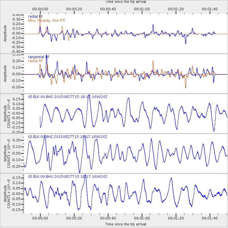
ELK Elko, Nevada, USA - Earthquake Result Viewer
*The percent match for this event was below the threshold and hence no stack was calculated.
| Earthquake location: |
Fiji Islands Region |
| Earthquake latitude/longitude: |
-19.8/-176.3 |
| Earthquake time(UTC): |
2015/08/27 (239) 15:06:25 GMT |
| Earthquake Depth: |
12 km |
| Earthquake Magnitude: |
5.4 MW |
| Earthquake Catalog/Contributor: |
ISC/ISC |
|
| Network: |
US United States National Seismic Network |
| Station: |
ELK Elko, Nevada, USA |
| Lat/Lon: |
40.74 N/115.24 W |
| Elevation: |
2210 m |
|
| Distance: |
82.7 deg |
| Az: |
42.081 deg |
| Baz: |
236.146 deg |
| Ray Param: |
$rayparam |
*The percent match for this event was below the threshold and hence was not used in the summary stack. |
|
| Radial Match: |
60.20111 % |
| Radial Bump: |
400 |
| Transverse Match: |
57.37813 % |
| Transverse Bump: |
377 |
| SOD ConfigId: |
7422571 |
| Insert Time: |
2019-04-20 14:43:05.692 +0000 |
| GWidth: |
2.5 |
| Max Bumps: |
400 |
| Tol: |
0.001 |
|
Signal To Noise
| Channel | StoN | STA | LTA |
| US:ELK:00:BHZ:20150827T15:18:17.169026Z | 1.6116071 | 1.3675502E-7 | 8.4856296E-8 |
| US:ELK:00:BH1:20150827T15:18:17.169026Z | 1.3898796 | 8.403278E-8 | 6.046047E-8 |
| US:ELK:00:BH2:20150827T15:18:17.169026Z | 1.8567953 | 1.0257269E-7 | 5.524179E-8 |
| Arrivals |
| Ps | |
| PpPs | |
| PsPs/PpSs | |


