You are here: Home > Network List > IU - Global Seismograph Network (GSN - IRIS/USGS) Stations List
> Station MAJO Matsushiro, Japan > Earthquake Result Viewer
MAJO Matsushiro, Japan - Earthquake Result Viewer
| Earthquake location: |
Santa Cruz Islands |
| Earthquake latitude/longitude: |
-11.3/165.4 |
| Earthquake time(UTC): |
2000/05/06 (127) 13:44:13 GMT |
| Earthquake Depth: |
12 km |
| Earthquake Magnitude: |
6.0 MB, 6.3 MS, 6.3 MW, 5.8 ME |
| Earthquake Catalog/Contributor: |
WHDF/NEIC |
|
| Network: |
IU Global Seismograph Network (GSN - IRIS/USGS) |
| Station: |
MAJO Matsushiro, Japan |
| Lat/Lon: |
36.54 N/138.21 E |
| Elevation: |
405 m |
|
| Distance: |
54.1 deg |
| Az: |
332.929 deg |
| Baz: |
146.337 deg |
| Ray Param: |
0.06568438 |
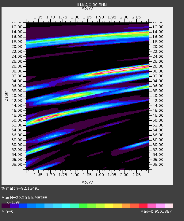
| Estimated Moho Depth: |
29.25 km |
| Estimated Crust Vp/Vs: |
1.99 |
| Assumed Crust Vp: |
6.461 km/s |
| Estimated Crust Vs: |
3.247 km/s |
| Estimated Crust Poisson's Ratio: |
0.33 |
|
| Radial Match: |
92.15491 % |
| Radial Bump: |
400 |
| Transverse Match: |
85.06666 % |
| Transverse Bump: |
400 |
| SOD ConfigId: |
3744 |
| Insert Time: |
2010-03-04 16:10:19.252 +0000 |
| GWidth: |
2.5 |
| Max Bumps: |
400 |
| Tol: |
0.001 |
|
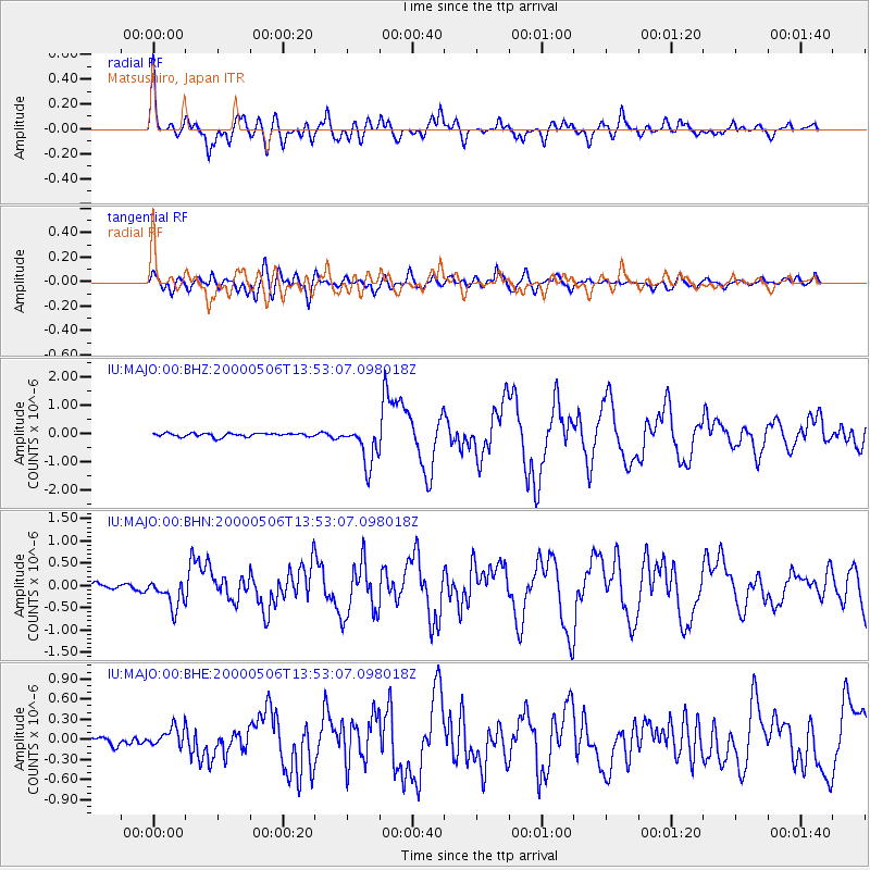
Signal To Noise
| Channel | StoN | STA | LTA |
| IU:MAJO:00:BHN:20000506T13:53:07.098018Z | 3.5094364 | 3.1358667E-7 | 8.9355275E-8 |
| IU:MAJO:00:BHE:20000506T13:53:07.098018Z | 2.4308476 | 1.4284224E-7 | 5.8762318E-8 |
| IU:MAJO:00:BHZ:20000506T13:53:07.098018Z | 11.3858 | 7.0179306E-7 | 6.1637564E-8 |
| Arrivals |
| Ps | 4.7 SECOND |
| PpPs | 13 SECOND |
| PsPs/PpSs | 18 SECOND |


