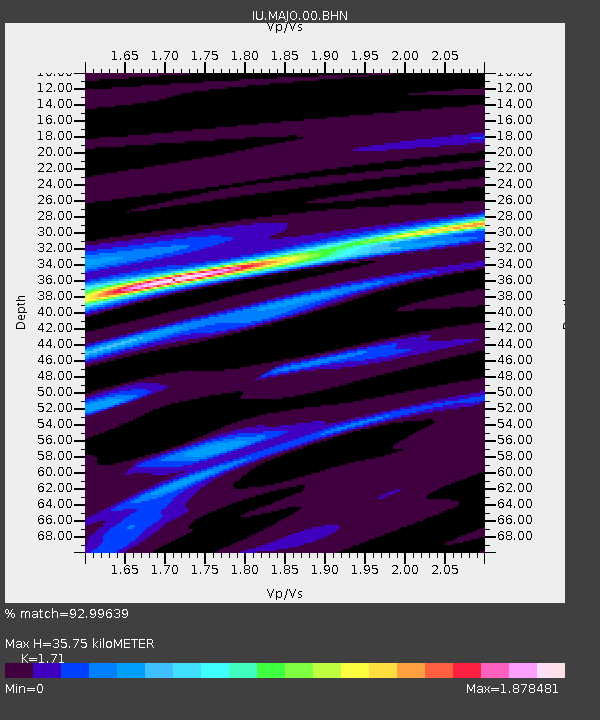
MAJO Matsushiro, Japan - Earthquake Result Viewer
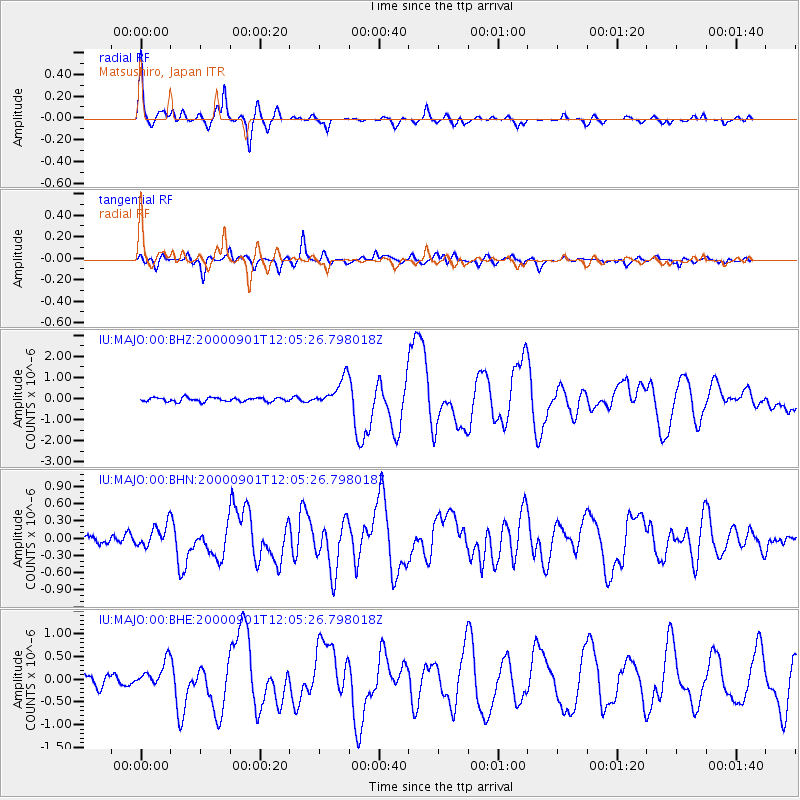
Earthquake location: Off W Coast Of Northern Sumatra
Earthquake latitude/longitude: 1.4/96.6
Earthquake time(UTC): 2000/09/01 (245) 11:56:51 GMT
Earthquake Depth: 33 km
Earthquake Magnitude: 5.6 MB, 6.0 MS, 6.2 MW, 6.0 MW
Earthquake Catalog/Contributor: WHDF/NEIC
Network: IU Global Seismograph Network (GSN - IRIS/USGS)
Station: MAJO Matsushiro, Japan
Lat/Lon: 36.54 N/138.21 E
Elevation: 405 m
Distance: 51.9 deg
Az: 42.797 deg
Baz: 237.498 deg
Ray Param: 0.067027725
Estimated Moho Depth: 35.75 km
Estimated Crust Vp/Vs: 1.71
Assumed Crust Vp: 6.461 km/s
Estimated Crust Vs: 3.779 km/s
Estimated Crust Poisson's Ratio: 0.24
Radial Match: 92.99639 %
Radial Bump: 398
Transverse Match: 89.80118 %
Transverse Bump: 400
SOD ConfigId: 3744
Insert Time: 2010-03-04 16:10:23.921 +0000
GWidth: 2.5
Max Bumps: 400
Tol: 0.001

Signal To Noise

ChannelStoNSTALTA
IU:MAJO:00:BHN:20000901T12:05:26.798018Z2.7909771.99216E-77.137859E-8
IU:MAJO:00:BHE:20000901T12:05:26.798018Z2.57550332.8839946E-71.119779E-7
IU:MAJO:00:BHZ:20000901T12:05:26.798018Z7.27714876.7409735E-79.2632064E-8
Arrivals
Ps4.2 SECOND
PpPs14 SECOND
PsPs/PpSs18 SECOND