You are here: Home > Network List > IU - Global Seismograph Network (GSN - IRIS/USGS) Stations List
> Station MAJO Matsushiro, Japan > Earthquake Result Viewer
MAJO Matsushiro, Japan - Earthquake Result Viewer
| Earthquake location: |
Northern Molucca Sea |
| Earthquake latitude/longitude: |
1.1/126.4 |
| Earthquake time(UTC): |
2001/08/27 (239) 01:16:47 GMT |
| Earthquake Depth: |
33 km |
| Earthquake Magnitude: |
5.8 MB, 5.9 MS, 6.1 MW, 5.9 MW |
| Earthquake Catalog/Contributor: |
WHDF/NEIC |
|
| Network: |
IU Global Seismograph Network (GSN - IRIS/USGS) |
| Station: |
MAJO Matsushiro, Japan |
| Lat/Lon: |
36.54 N/138.21 E |
| Elevation: |
405 m |
|
| Distance: |
36.9 deg |
| Az: |
15.968 deg |
| Baz: |
199.97 deg |
| Ray Param: |
0.07634473 |
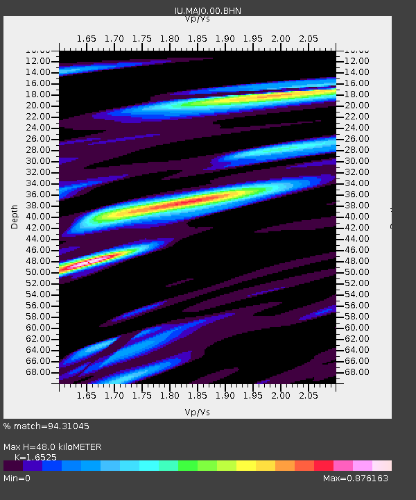
| Estimated Moho Depth: |
48.0 km |
| Estimated Crust Vp/Vs: |
1.65 |
| Assumed Crust Vp: |
6.461 km/s |
| Estimated Crust Vs: |
3.91 km/s |
| Estimated Crust Poisson's Ratio: |
0.21 |
|
| Radial Match: |
94.31045 % |
| Radial Bump: |
332 |
| Transverse Match: |
82.1422 % |
| Transverse Bump: |
391 |
| SOD ConfigId: |
20082 |
| Insert Time: |
2010-03-04 16:10:49.373 +0000 |
| GWidth: |
2.5 |
| Max Bumps: |
400 |
| Tol: |
0.001 |
|

Signal To Noise
| Channel | StoN | STA | LTA |
| IU:MAJO:00:BHN:20010827T01:23:22.986011Z | 7.5420113 | 8.962907E-7 | 1.1883974E-7 |
| IU:MAJO:00:BHE:20010827T01:23:22.986011Z | 3.000524 | 3.6726203E-7 | 1.223993E-7 |
| IU:MAJO:00:BHZ:20010827T01:23:22.986011Z | 11.152998 | 1.60926E-6 | 1.4428946E-7 |
| Arrivals |
| Ps | 5.3 SECOND |
| PpPs | 18 SECOND |
| PsPs/PpSs | 23 SECOND |


