You are here: Home > Network List > IU - Global Seismograph Network (GSN - IRIS/USGS) Stations List
> Station MAJO Matsushiro, Japan > Earthquake Result Viewer
MAJO Matsushiro, Japan - Earthquake Result Viewer
| Earthquake location: |
Bismarck Sea |
| Earthquake latitude/longitude: |
-3.4/146.3 |
| Earthquake time(UTC): |
2001/08/23 (235) 21:45:03 GMT |
| Earthquake Depth: |
10 km |
| Earthquake Magnitude: |
5.8 MB, 6.2 MS, 6.2 MW, 6.0 MW |
| Earthquake Catalog/Contributor: |
WHDF/NEIC |
|
| Network: |
IU Global Seismograph Network (GSN - IRIS/USGS) |
| Station: |
MAJO Matsushiro, Japan |
| Lat/Lon: |
36.54 N/138.21 E |
| Elevation: |
405 m |
|
| Distance: |
40.4 deg |
| Az: |
349.917 deg |
| Baz: |
167.466 deg |
| Ray Param: |
0.07441055 |
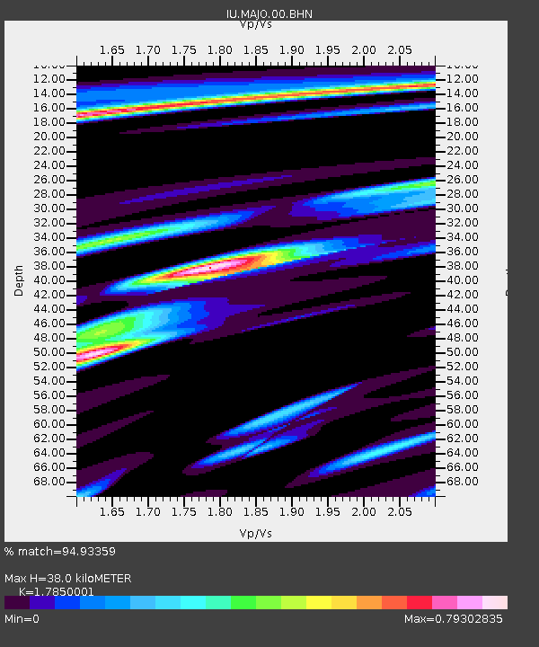
| Estimated Moho Depth: |
38.0 km |
| Estimated Crust Vp/Vs: |
1.79 |
| Assumed Crust Vp: |
6.461 km/s |
| Estimated Crust Vs: |
3.62 km/s |
| Estimated Crust Poisson's Ratio: |
0.27 |
|
| Radial Match: |
94.93359 % |
| Radial Bump: |
324 |
| Transverse Match: |
86.783394 % |
| Transverse Bump: |
394 |
| SOD ConfigId: |
20082 |
| Insert Time: |
2010-03-04 16:10:51.229 +0000 |
| GWidth: |
2.5 |
| Max Bumps: |
400 |
| Tol: |
0.001 |
|

Signal To Noise
| Channel | StoN | STA | LTA |
| IU:MAJO:00:BHN:20010823T21:52:10.636013Z | 5.214281 | 4.4865533E-7 | 8.604357E-8 |
| IU:MAJO:00:BHE:20010823T21:52:10.636013Z | 1.8967979 | 2.0995051E-7 | 1.1068682E-7 |
| IU:MAJO:00:BHZ:20010823T21:52:10.636013Z | 10.512809 | 9.990694E-7 | 9.5033535E-8 |
| Arrivals |
| Ps | 5.0 SECOND |
| PpPs | 15 SECOND |
| PsPs/PpSs | 20 SECOND |


