You are here: Home > Network List > IU - Global Seismograph Network (GSN - IRIS/USGS) Stations List
> Station MAJO Matsushiro, Japan > Earthquake Result Viewer
MAJO Matsushiro, Japan - Earthquake Result Viewer
| Earthquake location: |
Southern India |
| Earthquake latitude/longitude: |
23.4/70.2 |
| Earthquake time(UTC): |
2001/01/26 (026) 03:16:40 GMT |
| Earthquake Depth: |
16 km |
| Earthquake Magnitude: |
6.9 MB, 8.0 MS, 7.7 MW, 7.7 ME |
| Earthquake Catalog/Contributor: |
WHDF/NEIC |
|
| Network: |
IU Global Seismograph Network (GSN - IRIS/USGS) |
| Station: |
MAJO Matsushiro, Japan |
| Lat/Lon: |
36.54 N/138.21 E |
| Elevation: |
405 m |
|
| Distance: |
59.2 deg |
| Az: |
60.335 deg |
| Baz: |
277.628 deg |
| Ray Param: |
0.06231731 |
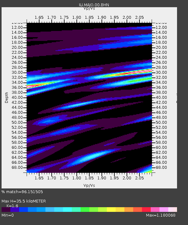
| Estimated Moho Depth: |
35.5 km |
| Estimated Crust Vp/Vs: |
1.60 |
| Assumed Crust Vp: |
6.461 km/s |
| Estimated Crust Vs: |
4.038 km/s |
| Estimated Crust Poisson's Ratio: |
0.18 |
|
| Radial Match: |
96.151505 % |
| Radial Bump: |
400 |
| Transverse Match: |
94.370285 % |
| Transverse Bump: |
400 |
| SOD ConfigId: |
3744 |
| Insert Time: |
2010-03-04 16:10:54.533 +0000 |
| GWidth: |
2.5 |
| Max Bumps: |
400 |
| Tol: |
0.001 |
|
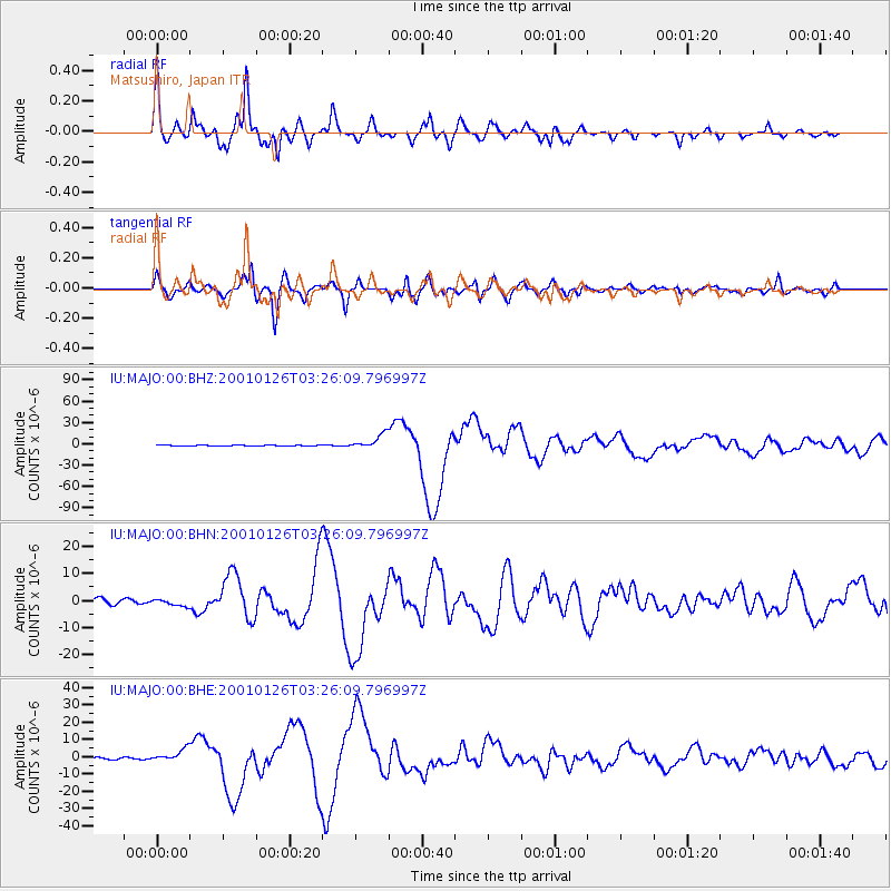
Signal To Noise
| Channel | StoN | STA | LTA |
| IU:MAJO:00:BHN:20010126T03:26:09.796997Z | 1.6426944 | 1.3571608E-6 | 8.2617976E-7 |
| IU:MAJO:00:BHE:20010126T03:26:09.796997Z | 4.700598 | 3.6675763E-6 | 7.802361E-7 |
| IU:MAJO:00:BHZ:20010126T03:26:09.796997Z | 19.32165 | 1.03797975E-5 | 5.372108E-7 |
| Arrivals |
| Ps | 3.5 SECOND |
| PpPs | 14 SECOND |
| PsPs/PpSs | 17 SECOND |


