You are here: Home > Network List > IU - Global Seismograph Network (GSN - IRIS/USGS) Stations List
> Station RSSD Black Hills, South Dakota, USA > Earthquake Result Viewer
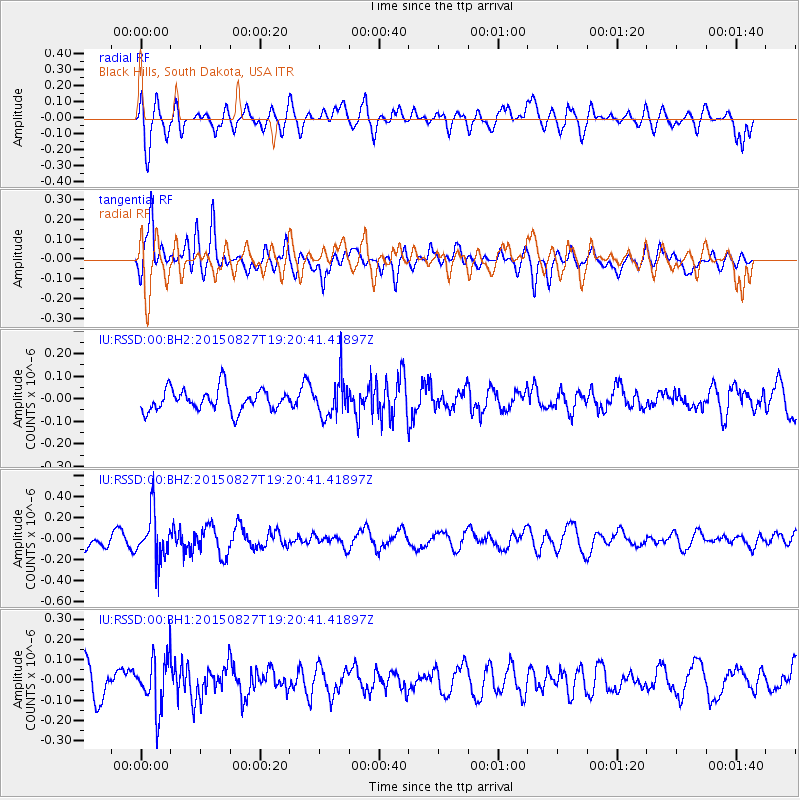
RSSD Black Hills, South Dakota, USA - Earthquake Result Viewer
*The percent match for this event was below the threshold and hence no stack was calculated.
| Earthquake location: |
Kuril Islands |
| Earthquake latitude/longitude: |
45.1/147.3 |
| Earthquake time(UTC): |
2015/08/27 (239) 19:10:10 GMT |
| Earthquake Depth: |
146 km |
| Earthquake Magnitude: |
5.1 MW |
| Earthquake Catalog/Contributor: |
ISC/ISC |
|
| Network: |
IU Global Seismograph Network (GSN - IRIS/USGS) |
| Station: |
RSSD Black Hills, South Dakota, USA |
| Lat/Lon: |
44.12 N/104.04 W |
| Elevation: |
2090 m |
|
| Distance: |
71.0 deg |
| Az: |
46.189 deg |
| Baz: |
314.76 deg |
| Ray Param: |
$rayparam |
*The percent match for this event was below the threshold and hence was not used in the summary stack. |
|
| Radial Match: |
46.983013 % |
| Radial Bump: |
400 |
| Transverse Match: |
59.43478 % |
| Transverse Bump: |
400 |
| SOD ConfigId: |
7422571 |
| Insert Time: |
2019-04-20 14:51:29.407 +0000 |
| GWidth: |
2.5 |
| Max Bumps: |
400 |
| Tol: |
0.001 |
|
Signal To Noise
| Channel | StoN | STA | LTA |
| IU:RSSD:00:BHZ:20150827T19:20:41.41897Z | 2.367423 | 2.2178216E-7 | 9.368083E-8 |
| IU:RSSD:00:BH1:20150827T19:20:41.41897Z | 1.7238284 | 1.3080087E-7 | 7.587812E-8 |
| IU:RSSD:00:BH2:20150827T19:20:41.41897Z | 1.6978892 | 8.214903E-8 | 4.8383033E-8 |
| Arrivals |
| Ps | |
| PpPs | |
| PsPs/PpSs | |


