You are here: Home > Network List > IW - Intermountain West Stations List
> Station MOOW Moose Ponds, Wyoming, USA > Earthquake Result Viewer
MOOW Moose Ponds, Wyoming, USA - Earthquake Result Viewer
*The percent match for this event was below the threshold and hence no stack was calculated.
| Earthquake location: |
Kuril Islands |
| Earthquake latitude/longitude: |
45.1/147.3 |
| Earthquake time(UTC): |
2015/08/27 (239) 19:10:10 GMT |
| Earthquake Depth: |
146 km |
| Earthquake Magnitude: |
5.1 MW |
| Earthquake Catalog/Contributor: |
ISC/ISC |
|
| Network: |
IW Intermountain West |
| Station: |
MOOW Moose Ponds, Wyoming, USA |
| Lat/Lon: |
43.75 N/110.74 W |
| Elevation: |
2128 m |
|
| Distance: |
67.7 deg |
| Az: |
50.018 deg |
| Baz: |
311.471 deg |
| Ray Param: |
$rayparam |
*The percent match for this event was below the threshold and hence was not used in the summary stack. |
|
| Radial Match: |
53.274143 % |
| Radial Bump: |
400 |
| Transverse Match: |
47.393085 % |
| Transverse Bump: |
371 |
| SOD ConfigId: |
7422571 |
| Insert Time: |
2019-04-20 14:51:36.874 +0000 |
| GWidth: |
2.5 |
| Max Bumps: |
400 |
| Tol: |
0.001 |
|
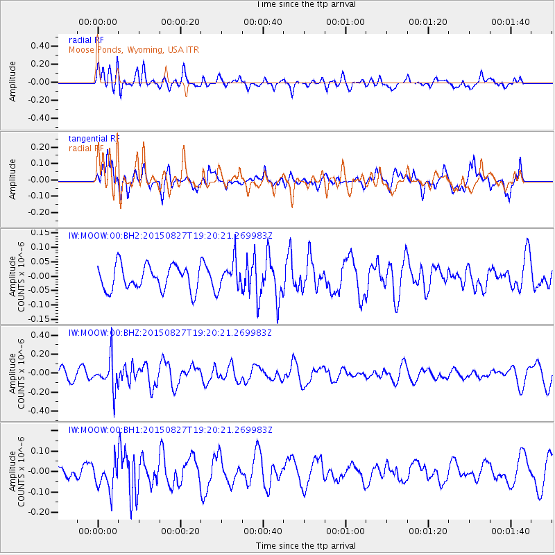
Signal To Noise
| Channel | StoN | STA | LTA |
| IW:MOOW:00:BHZ:20150827T19:20:21.269983Z | 2.6304429 | 1.6639655E-7 | 6.325799E-8 |
| IW:MOOW:00:BH1:20150827T19:20:21.269983Z | 2.2879152 | 7.051112E-8 | 3.081894E-8 |
| IW:MOOW:00:BH2:20150827T19:20:21.269983Z | 1.1405615 | 4.7829847E-8 | 4.193535E-8 |
| Arrivals |
| Ps | |
| PpPs | |
| PsPs/PpSs | |


