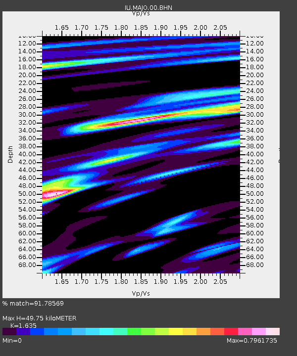
MAJO Matsushiro, Japan - Earthquake Result Viewer
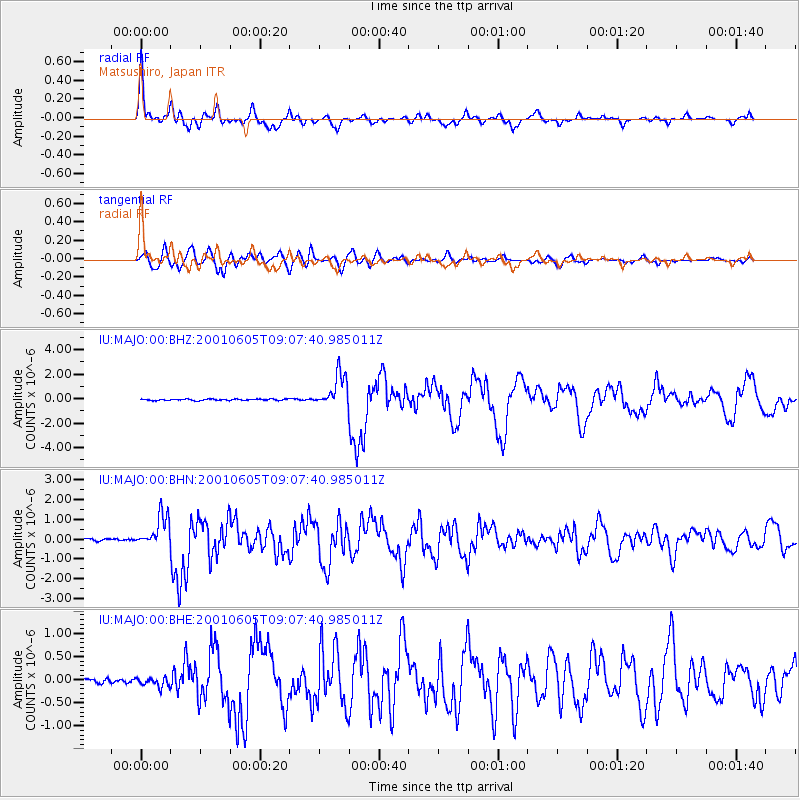
Earthquake location: Eastern New Guinea Reg., P.N.G.
Earthquake latitude/longitude: -6.9/146.4
Earthquake time(UTC): 2001/06/05 (156) 09:00:05 GMT
Earthquake Depth: 10 km
Earthquake Magnitude: 5.8 MB, 6.2 MS, 6.4 MW, 6.1 MW
Earthquake Catalog/Contributor: WHDF/NEIC
Network: IU Global Seismograph Network (GSN - IRIS/USGS)
Station: MAJO Matsushiro, Japan
Lat/Lon: 36.54 N/138.21 E
Elevation: 405 m
Distance: 43.9 deg
Az: 350.483 deg
Baz: 168.238 deg
Ray Param: 0.07226861
Estimated Moho Depth: 49.75 km
Estimated Crust Vp/Vs: 1.63
Assumed Crust Vp: 6.461 km/s
Estimated Crust Vs: 3.952 km/s
Estimated Crust Poisson's Ratio: 0.20
Radial Match: 91.78569 %
Radial Bump: 400
Transverse Match: 88.06753 %
Transverse Bump: 400
SOD ConfigId: 4714
Insert Time: 2010-03-04 16:11:24.303 +0000
GWidth: 2.5
Max Bumps: 400
Tol: 0.001

Signal To Noise

ChannelStoNSTALTA
IU:MAJO:00:BHN:20010605T09:07:40.985011Z17.751528.033679E-74.525629E-8
IU:MAJO:00:BHE:20010605T09:07:40.985011Z1.94997649.895897E-85.0748806E-8
IU:MAJO:00:BHZ:20010605T09:07:40.985011Z23.6473371.3360306E-65.6498138E-8
Arrivals
Ps5.3 SECOND
PpPs19 SECOND
PsPs/PpSs24 SECOND