You are here: Home > Network List > IU - Global Seismograph Network (GSN - IRIS/USGS) Stations List
> Station MAJO Matsushiro, Japan > Earthquake Result Viewer
MAJO Matsushiro, Japan - Earthquake Result Viewer
| Earthquake location: |
Eastern New Guinea Reg., P.N.G. |
| Earthquake latitude/longitude: |
-6.4/146.8 |
| Earthquake time(UTC): |
2001/06/30 (181) 16:34:36 GMT |
| Earthquake Depth: |
104 km |
| Earthquake Magnitude: |
5.8 MB, 6.0 MW, 6.0 MW |
| Earthquake Catalog/Contributor: |
WHDF/NEIC |
|
| Network: |
IU Global Seismograph Network (GSN - IRIS/USGS) |
| Station: |
MAJO Matsushiro, Japan |
| Lat/Lon: |
36.54 N/138.21 E |
| Elevation: |
405 m |
|
| Distance: |
43.5 deg |
| Az: |
349.973 deg |
| Baz: |
167.592 deg |
| Ray Param: |
0.07216515 |
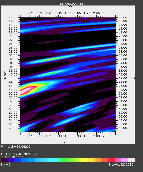
| Estimated Moho Depth: |
48.25 km |
| Estimated Crust Vp/Vs: |
1.62 |
| Assumed Crust Vp: |
6.461 km/s |
| Estimated Crust Vs: |
3.995 km/s |
| Estimated Crust Poisson's Ratio: |
0.19 |
|
| Radial Match: |
89.06233 % |
| Radial Bump: |
400 |
| Transverse Match: |
83.56428 % |
| Transverse Bump: |
400 |
| SOD ConfigId: |
4714 |
| Insert Time: |
2010-03-04 16:11:28.489 +0000 |
| GWidth: |
2.5 |
| Max Bumps: |
400 |
| Tol: |
0.001 |
|

Signal To Noise
| Channel | StoN | STA | LTA |
| IU:MAJO:00:BHN:20010630T16:41:58.534987Z | 4.1330442 | 7.40414E-7 | 1.7914495E-7 |
| IU:MAJO:00:BHE:20010630T16:41:58.534987Z | 3.3586419 | 3.4804728E-7 | 1.03627386E-7 |
| IU:MAJO:00:BHZ:20010630T16:41:58.534987Z | 7.0291305 | 1.0354155E-6 | 1.473035E-7 |
| Arrivals |
| Ps | 5.0 SECOND |
| PpPs | 18 SECOND |
| PsPs/PpSs | 23 SECOND |


