MAJO Matsushiro, Japan - Earthquake Result Viewer
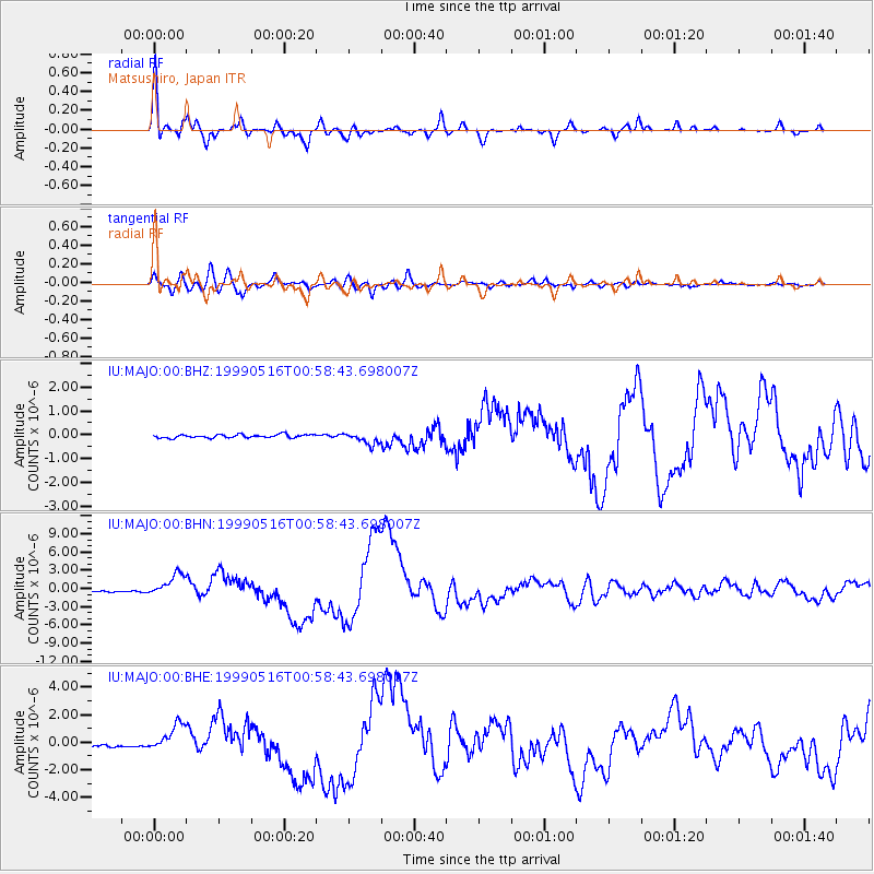
Earthquake location: New Britain Region, P.N.G.
Earthquake latitude/longitude: -4.8/152.5
Earthquake time(UTC): 1999/05/16 (136) 00:51:20 GMT
Earthquake Depth: 74 km
Earthquake Magnitude: 6.0 MB, 7.0 MS, 7.1 MW, 6.3 ME
Earthquake Catalog/Contributor: WHDF/NEIC
Network: IU Global Seismograph Network (GSN - IRIS/USGS)
Station: MAJO Matsushiro, Japan
Lat/Lon: 36.54 N/138.21 E
Elevation: 405 m
Distance: 43.2 deg
Az: 343.131 deg
Baz: 158.955 deg
Ray Param: 0.0724706
Estimated Moho Depth: 49.75 km
Estimated Crust Vp/Vs: 1.60
Assumed Crust Vp: 6.461 km/s
Estimated Crust Vs: 4.032 km/s
Estimated Crust Poisson's Ratio: 0.18
Radial Match: 97.34487 %
Radial Bump: 394
Transverse Match: 90.05056 %
Transverse Bump: 400
SOD ConfigId: 4480
Insert Time: 2010-03-04 16:11:38.286 +0000
GWidth: 2.5
Max Bumps: 400
Tol: 0.001

Signal To Noise

ChannelStoNSTALTA
IU:MAJO:00:BHN:19990516T00:58:43.698007Z12.0158491.8468452E-61.5370077E-7
IU:MAJO:00:BHE:19990516T00:58:43.698007Z8.6319081.0010395E-61.1596967E-7
IU:MAJO:00:BHZ:19990516T00:58:43.698007Z3.52810382.4695748E-76.999723E-8
Arrivals
Ps5.0 SECOND
PpPs19 SECOND
PsPs/PpSs24 SECOND