You are here: Home > Network List > TA - USArray Transportable Network (new EarthScope stations) Stations List
> Station G03D McMinnville, OR, USA > Earthquake Result Viewer
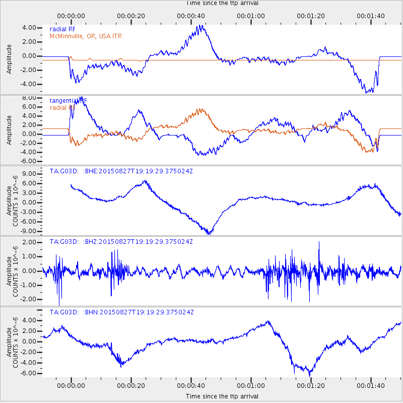
G03D McMinnville, OR, USA - Earthquake Result Viewer
*The percent match for this event was below the threshold and hence no stack was calculated.
| Earthquake location: |
Kuril Islands |
| Earthquake latitude/longitude: |
45.1/147.3 |
| Earthquake time(UTC): |
2015/08/27 (239) 19:10:10 GMT |
| Earthquake Depth: |
146 km |
| Earthquake Magnitude: |
5.1 MW |
| Earthquake Catalog/Contributor: |
ISC/ISC |
|
| Network: |
TA USArray Transportable Network (new EarthScope stations) |
| Station: |
G03D McMinnville, OR, USA |
| Lat/Lon: |
45.21 N/123.26 W |
| Elevation: |
222 m |
|
| Distance: |
59.8 deg |
| Az: |
54.911 deg |
| Baz: |
304.883 deg |
| Ray Param: |
$rayparam |
*The percent match for this event was below the threshold and hence was not used in the summary stack. |
|
| Radial Match: |
49.09677 % |
| Radial Bump: |
400 |
| Transverse Match: |
44.99273 % |
| Transverse Bump: |
400 |
| SOD ConfigId: |
7422571 |
| Insert Time: |
2019-04-20 14:54:55.943 +0000 |
| GWidth: |
2.5 |
| Max Bumps: |
400 |
| Tol: |
0.001 |
|
Signal To Noise
| Channel | StoN | STA | LTA |
| TA:G03D: :BHZ:20150827T19:19:29.375024Z | 1.2200971 | 2.3273957E-7 | 1.9075496E-7 |
| TA:G03D: :BHN:20150827T19:19:29.375024Z | 0.981156 | 1.2235757E-6 | 1.2470757E-6 |
| TA:G03D: :BHE:20150827T19:19:29.375024Z | 1.6853236 | 3.0520002E-6 | 1.8109282E-6 |
| Arrivals |
| Ps | |
| PpPs | |
| PsPs/PpSs | |


