You are here: Home > Network List > TA - USArray Transportable Network (new EarthScope stations) Stations List
> Station J20K Nowitna River, AK, USA > Earthquake Result Viewer
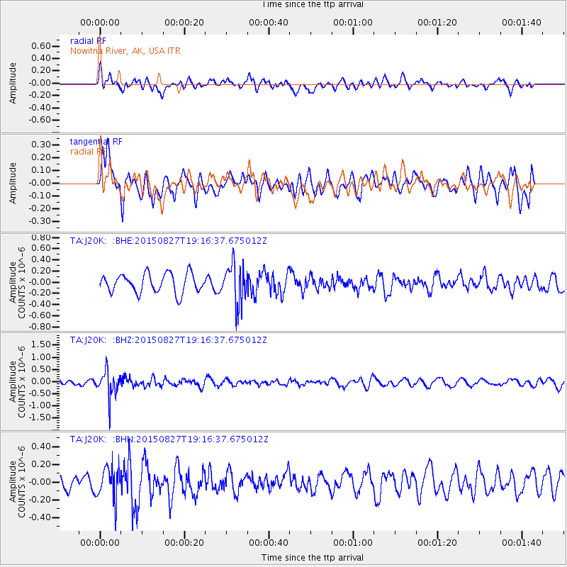
J20K Nowitna River, AK, USA - Earthquake Result Viewer
*The percent match for this event was below the threshold and hence no stack was calculated.
| Earthquake location: |
Kuril Islands |
| Earthquake latitude/longitude: |
45.1/147.3 |
| Earthquake time(UTC): |
2015/08/27 (239) 19:10:10 GMT |
| Earthquake Depth: |
146 km |
| Earthquake Magnitude: |
5.1 MW |
| Earthquake Catalog/Contributor: |
ISC/ISC |
|
| Network: |
TA USArray Transportable Network (new EarthScope stations) |
| Station: |
J20K Nowitna River, AK, USA |
| Lat/Lon: |
64.18 N/154.15 W |
| Elevation: |
314 m |
|
| Distance: |
37.2 deg |
| Az: |
38.14 deg |
| Baz: |
267.812 deg |
| Ray Param: |
$rayparam |
*The percent match for this event was below the threshold and hence was not used in the summary stack. |
|
| Radial Match: |
34.011948 % |
| Radial Bump: |
400 |
| Transverse Match: |
65.28944 % |
| Transverse Bump: |
400 |
| SOD ConfigId: |
7422571 |
| Insert Time: |
2019-04-20 14:55:04.528 +0000 |
| GWidth: |
2.5 |
| Max Bumps: |
400 |
| Tol: |
0.001 |
|
Signal To Noise
| Channel | StoN | STA | LTA |
| TA:J20K: :BHZ:20150827T19:16:37.675012Z | 4.603207 | 5.1800765E-7 | 1.1253189E-7 |
| TA:J20K: :BHN:20150827T19:16:37.675012Z | 1.7557725 | 1.825859E-7 | 1.0399177E-7 |
| TA:J20K: :BHE:20150827T19:16:37.675012Z | 2.0991242 | 3.5721382E-7 | 1.701728E-7 |
| Arrivals |
| Ps | |
| PpPs | |
| PsPs/PpSs | |


