You are here: Home > Network List > IU - Global Seismograph Network (GSN - IRIS/USGS) Stations List
> Station MAJO Matsushiro, Japan > Earthquake Result Viewer
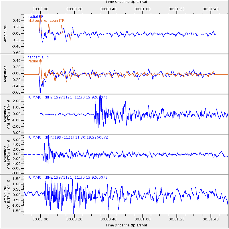
MAJO Matsushiro, Japan - Earthquake Result Viewer
*The percent match for this event was below the threshold and hence no stack was calculated.
| Earthquake location: |
India-Bangladesh Border Region |
| Earthquake latitude/longitude: |
22.2/92.7 |
| Earthquake time(UTC): |
1997/11/21 (325) 11:23:06 GMT |
| Earthquake Depth: |
54 km |
| Earthquake Magnitude: |
5.9 MB, 6.1 UNKNOWN, 6.1 MW |
| Earthquake Catalog/Contributor: |
WHDF/NEIC |
|
| Network: |
IU Global Seismograph Network (GSN - IRIS/USGS) |
| Station: |
MAJO Matsushiro, Japan |
| Lat/Lon: |
36.54 N/138.21 E |
| Elevation: |
405 m |
|
| Distance: |
41.8 deg |
| Az: |
59.585 deg |
| Baz: |
262.9 deg |
| Ray Param: |
$rayparam |
*The percent match for this event was below the threshold and hence was not used in the summary stack. |
|
| Radial Match: |
71.63595 % |
| Radial Bump: |
400 |
| Transverse Match: |
77.83071 % |
| Transverse Bump: |
400 |
| SOD ConfigId: |
4480 |
| Insert Time: |
2010-03-04 16:11:45.818 +0000 |
| GWidth: |
2.5 |
| Max Bumps: |
400 |
| Tol: |
0.001 |
|
Signal To Noise
| Channel | StoN | STA | LTA |
| IU:MAJO: :BHN:19971121T11:30:19.926007Z | 4.1986074 | 2.2118447E-6 | 5.2680434E-7 |
| IU:MAJO: :BHE:19971121T11:30:19.926007Z | 1.0028689 | 8.218324E-7 | 8.194814E-7 |
| IU:MAJO: :BHZ:19971121T11:30:19.926007Z | 10.053782 | 9.604828E-7 | 9.553447E-8 |
| Arrivals |
| Ps | |
| PpPs | |
| PsPs/PpSs | |


