You are here: Home > Network List > TA - USArray Transportable Network (new EarthScope stations) Stations List
> Station N02D Trinity Center, CA, USA > Earthquake Result Viewer
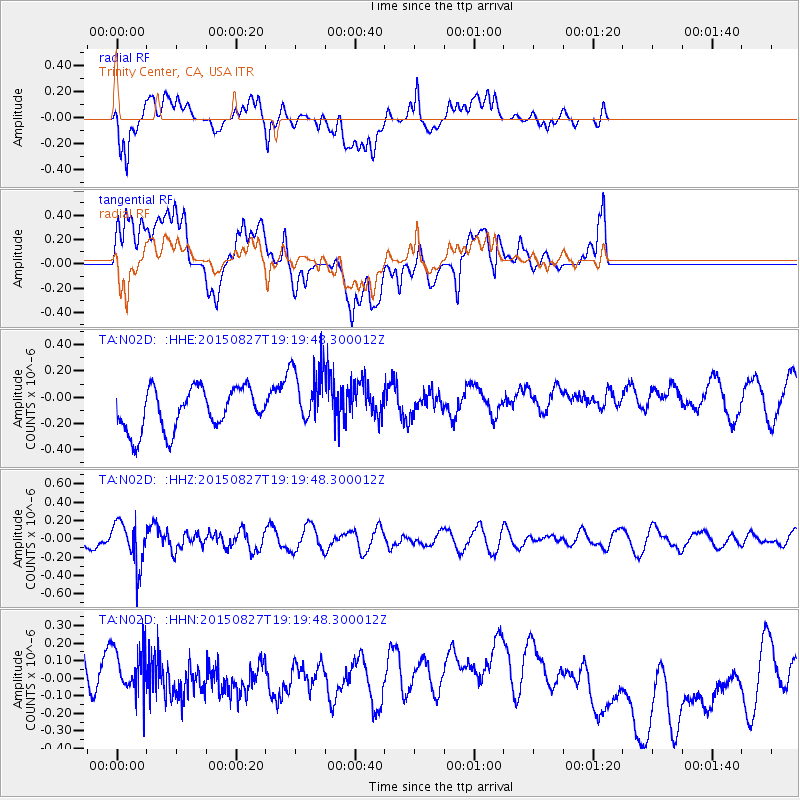
N02D Trinity Center, CA, USA - Earthquake Result Viewer
*The percent match for this event was below the threshold and hence no stack was calculated.
| Earthquake location: |
Kuril Islands |
| Earthquake latitude/longitude: |
45.1/147.3 |
| Earthquake time(UTC): |
2015/08/27 (239) 19:10:10 GMT |
| Earthquake Depth: |
146 km |
| Earthquake Magnitude: |
5.1 MW |
| Earthquake Catalog/Contributor: |
ISC/ISC |
|
| Network: |
TA USArray Transportable Network (new EarthScope stations) |
| Station: |
N02D Trinity Center, CA, USA |
| Lat/Lon: |
40.97 N/122.71 W |
| Elevation: |
937 m |
|
| Distance: |
62.6 deg |
| Az: |
58.55 deg |
| Baz: |
307.02 deg |
| Ray Param: |
$rayparam |
*The percent match for this event was below the threshold and hence was not used in the summary stack. |
|
| Radial Match: |
49.584118 % |
| Radial Bump: |
400 |
| Transverse Match: |
30.115383 % |
| Transverse Bump: |
400 |
| SOD ConfigId: |
7422571 |
| Insert Time: |
2019-04-20 14:55:18.584 +0000 |
| GWidth: |
2.5 |
| Max Bumps: |
400 |
| Tol: |
0.001 |
|
Signal To Noise
| Channel | StoN | STA | LTA |
| TA:N02D: :HHZ:20150827T19:19:48.300012Z | 2.1155982 | 2.4165067E-7 | 1.1422333E-7 |
| TA:N02D: :HHN:20150827T19:19:48.300012Z | 0.9471961 | 2.7293973E-7 | 2.8815546E-7 |
| TA:N02D: :HHE:20150827T19:19:48.300012Z | 1.5592111 | 2.4672238E-7 | 1.582354E-7 |
| Arrivals |
| Ps | |
| PpPs | |
| PsPs/PpSs | |


