You are here: Home > Network List > IU - Global Seismograph Network (GSN - IRIS/USGS) Stations List
> Station MAJO Matsushiro, Japan > Earthquake Result Viewer
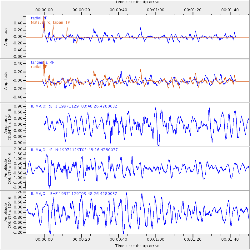
MAJO Matsushiro, Japan - Earthquake Result Viewer
*The percent match for this event was below the threshold and hence no stack was calculated.
| Earthquake location: |
Northern Molucca Sea |
| Earthquake latitude/longitude: |
2.2/126.6 |
| Earthquake time(UTC): |
1997/11/29 (333) 03:42:01 GMT |
| Earthquake Depth: |
43 km |
| Earthquake Magnitude: |
5.5 MB, 5.4 MS |
| Earthquake Catalog/Contributor: |
WHDF/NEIC |
|
| Network: |
IU Global Seismograph Network (GSN - IRIS/USGS) |
| Station: |
MAJO Matsushiro, Japan |
| Lat/Lon: |
36.54 N/138.21 E |
| Elevation: |
405 m |
|
| Distance: |
35.8 deg |
| Az: |
16.017 deg |
| Baz: |
200.022 deg |
| Ray Param: |
$rayparam |
*The percent match for this event was below the threshold and hence was not used in the summary stack. |
|
| Radial Match: |
65.62102 % |
| Radial Bump: |
400 |
| Transverse Match: |
51.323235 % |
| Transverse Bump: |
400 |
| SOD ConfigId: |
4480 |
| Insert Time: |
2010-03-04 16:11:47.303 +0000 |
| GWidth: |
2.5 |
| Max Bumps: |
400 |
| Tol: |
0.001 |
|
Signal To Noise
| Channel | StoN | STA | LTA |
| IU:MAJO: :BHN:19971129T03:48:26.428003Z | 2.6408558 | 1.0335332E-6 | 3.91363E-7 |
| IU:MAJO: :BHE:19971129T03:48:26.428003Z | 2.179975 | 6.247317E-7 | 2.8657743E-7 |
| IU:MAJO: :BHZ:19971129T03:48:26.428003Z | 1.0321183 | 3.185383E-7 | 3.0862577E-7 |
| Arrivals |
| Ps | |
| PpPs | |
| PsPs/PpSs | |


