You are here: Home > Network List > TA - USArray Transportable Network (new EarthScope stations) Stations List
> Station O03E Paynes Creek, CA, USA > Earthquake Result Viewer
O03E Paynes Creek, CA, USA - Earthquake Result Viewer
*The percent match for this event was below the threshold and hence no stack was calculated.
| Earthquake location: |
Kuril Islands |
| Earthquake latitude/longitude: |
45.1/147.3 |
| Earthquake time(UTC): |
2015/08/27 (239) 19:10:10 GMT |
| Earthquake Depth: |
146 km |
| Earthquake Magnitude: |
5.1 MW |
| Earthquake Catalog/Contributor: |
ISC/ISC |
|
| Network: |
TA USArray Transportable Network (new EarthScope stations) |
| Station: |
O03E Paynes Creek, CA, USA |
| Lat/Lon: |
40.29 N/121.80 W |
| Elevation: |
967 m |
|
| Distance: |
63.5 deg |
| Az: |
58.688 deg |
| Baz: |
307.668 deg |
| Ray Param: |
$rayparam |
*The percent match for this event was below the threshold and hence was not used in the summary stack. |
|
| Radial Match: |
43.82248 % |
| Radial Bump: |
400 |
| Transverse Match: |
46.648808 % |
| Transverse Bump: |
400 |
| SOD ConfigId: |
7422571 |
| Insert Time: |
2019-04-20 14:55:20.034 +0000 |
| GWidth: |
2.5 |
| Max Bumps: |
400 |
| Tol: |
0.001 |
|
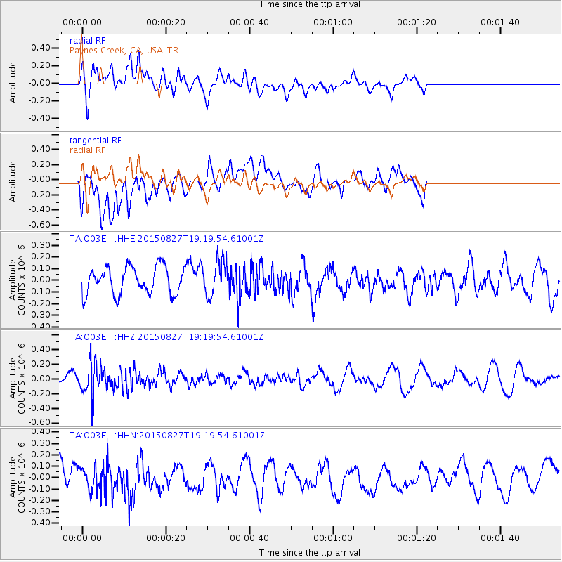
Signal To Noise
| Channel | StoN | STA | LTA |
| TA:O03E: :HHZ:20150827T19:19:54.61001Z | 2.6173859 | 2.2506276E-7 | 8.5987615E-8 |
| TA:O03E: :HHN:20150827T19:19:54.61001Z | 0.915267 | 1.0551575E-7 | 1.15284124E-7 |
| TA:O03E: :HHE:20150827T19:19:54.61001Z | 1.2491544 | 1.4556569E-7 | 1.1653137E-7 |
| Arrivals |
| Ps | |
| PpPs | |
| PsPs/PpSs | |


