You are here: Home > Network List > TA - USArray Transportable Network (new EarthScope stations) Stations List
> Station W41B Gary Mavity, Velonia, AR, USA > Earthquake Result Viewer
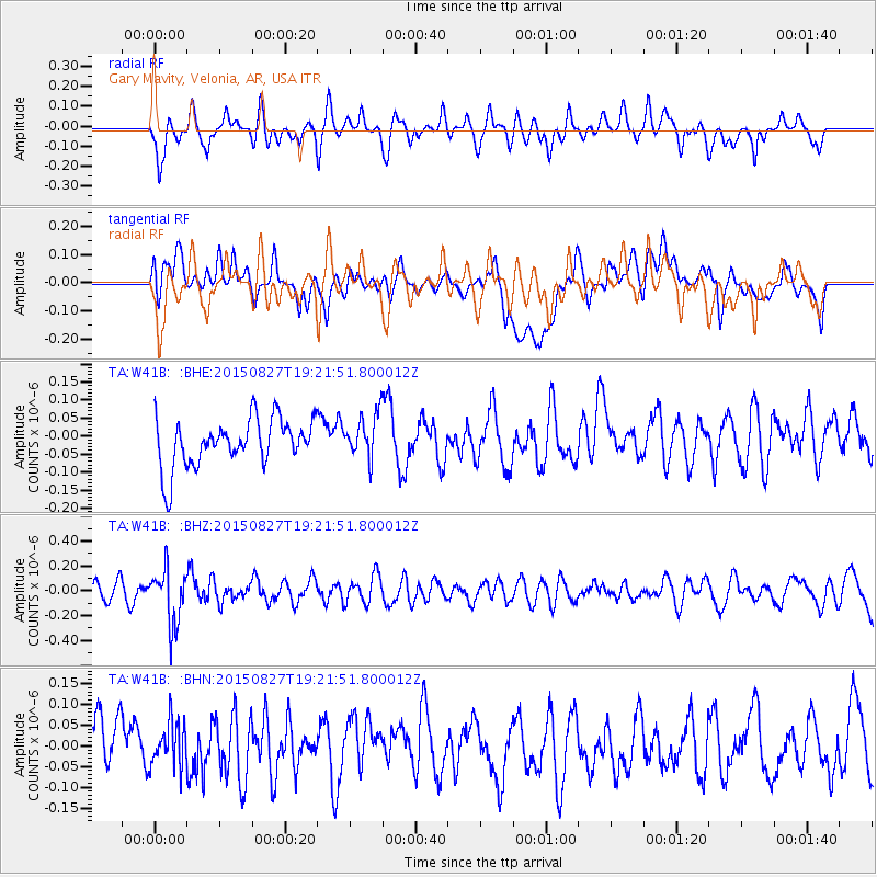
W41B Gary Mavity, Velonia, AR, USA - Earthquake Result Viewer
*The percent match for this event was below the threshold and hence no stack was calculated.
| Earthquake location: |
Kuril Islands |
| Earthquake latitude/longitude: |
45.1/147.3 |
| Earthquake time(UTC): |
2015/08/27 (239) 19:10:10 GMT |
| Earthquake Depth: |
146 km |
| Earthquake Magnitude: |
5.1 MW |
| Earthquake Catalog/Contributor: |
ISC/ISC |
|
| Network: |
TA USArray Transportable Network (new EarthScope stations) |
| Station: |
W41B Gary Mavity, Velonia, AR, USA |
| Lat/Lon: |
35.17 N/92.25 W |
| Elevation: |
95 m |
|
| Distance: |
83.7 deg |
| Az: |
45.263 deg |
| Baz: |
322.086 deg |
| Ray Param: |
$rayparam |
*The percent match for this event was below the threshold and hence was not used in the summary stack. |
|
| Radial Match: |
55.75483 % |
| Radial Bump: |
400 |
| Transverse Match: |
46.36727 % |
| Transverse Bump: |
400 |
| SOD ConfigId: |
7422571 |
| Insert Time: |
2019-04-20 14:55:30.007 +0000 |
| GWidth: |
2.5 |
| Max Bumps: |
400 |
| Tol: |
0.001 |
|
Signal To Noise
| Channel | StoN | STA | LTA |
| TA:W41B: :BHZ:20150827T19:21:51.800012Z | 2.1132138 | 2.1821887E-7 | 1.0326398E-7 |
| TA:W41B: :BHN:20150827T19:21:51.800012Z | 0.6948841 | 5.913233E-8 | 8.509667E-8 |
| TA:W41B: :BHE:20150827T19:21:51.800012Z | 0.9453403 | 6.222141E-8 | 6.581906E-8 |
| Arrivals |
| Ps | |
| PpPs | |
| PsPs/PpSs | |


