You are here: Home > Network List > IU - Global Seismograph Network (GSN - IRIS/USGS) Stations List
> Station MAJO Matsushiro, Japan > Earthquake Result Viewer
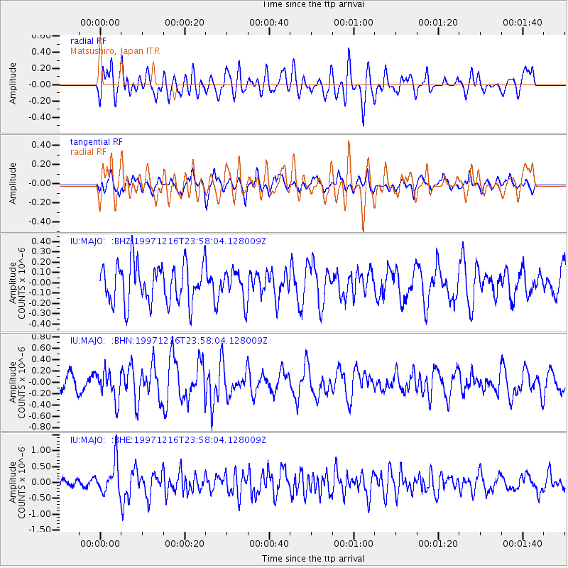
MAJO Matsushiro, Japan - Earthquake Result Viewer
*The percent match for this event was below the threshold and hence no stack was calculated.
| Earthquake location: |
Eastern New Guinea Reg., P.N.G. |
| Earthquake latitude/longitude: |
-5.9/147.2 |
| Earthquake time(UTC): |
1997/12/16 (350) 23:50:45 GMT |
| Earthquake Depth: |
103 km |
| Earthquake Magnitude: |
5.7 MB, 5.8 UNKNOWN, 5.8 MW |
| Earthquake Catalog/Contributor: |
WHDF/NEIC |
|
| Network: |
IU Global Seismograph Network (GSN - IRIS/USGS) |
| Station: |
MAJO Matsushiro, Japan |
| Lat/Lon: |
36.54 N/138.21 E |
| Elevation: |
405 m |
|
| Distance: |
43.0 deg |
| Az: |
349.407 deg |
| Baz: |
166.874 deg |
| Ray Param: |
$rayparam |
*The percent match for this event was below the threshold and hence was not used in the summary stack. |
|
| Radial Match: |
55.002758 % |
| Radial Bump: |
400 |
| Transverse Match: |
63.514557 % |
| Transverse Bump: |
400 |
| SOD ConfigId: |
4480 |
| Insert Time: |
2010-03-04 16:11:50.006 +0000 |
| GWidth: |
2.5 |
| Max Bumps: |
400 |
| Tol: |
0.001 |
|
Signal To Noise
| Channel | StoN | STA | LTA |
| IU:MAJO: :BHN:19971216T23:58:04.128009Z | 2.3472633 | 2.550174E-7 | 1.08644564E-7 |
| IU:MAJO: :BHE:19971216T23:58:04.128009Z | 4.117034 | 5.107548E-7 | 1.2405893E-7 |
| IU:MAJO: :BHZ:19971216T23:58:04.128009Z | 0.7721221 | 1.4583632E-7 | 1.8887728E-7 |
| Arrivals |
| Ps | |
| PpPs | |
| PsPs/PpSs | |


