You are here: Home > Network List > IU - Global Seismograph Network (GSN - IRIS/USGS) Stations List
> Station MAJO Matsushiro, Japan > Earthquake Result Viewer
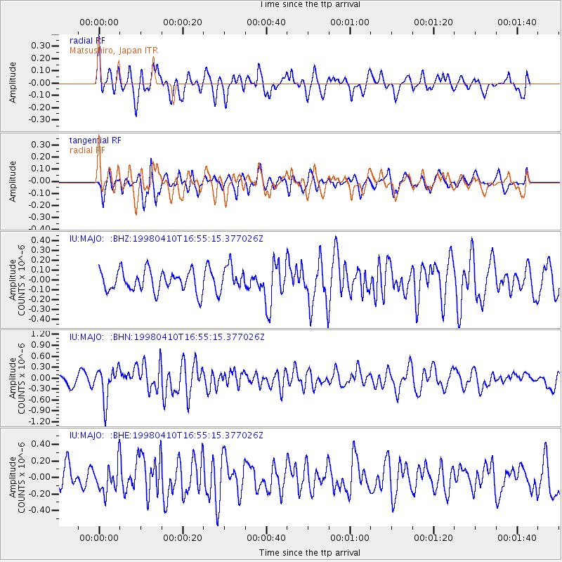
MAJO Matsushiro, Japan - Earthquake Result Viewer
*The percent match for this event was below the threshold and hence no stack was calculated.
| Earthquake location: |
South Of Kermadec Islands |
| Earthquake latitude/longitude: |
-33.5/-179.5 |
| Earthquake time(UTC): |
1998/04/10 (100) 16:43:41 GMT |
| Earthquake Depth: |
46 km |
| Earthquake Magnitude: |
5.9 MB, 5.9 MS, 6.0 UNKNOWN, 6.0 MW |
| Earthquake Catalog/Contributor: |
WHDF/NEIC |
|
| Network: |
IU Global Seismograph Network (GSN - IRIS/USGS) |
| Station: |
MAJO Matsushiro, Japan |
| Lat/Lon: |
36.54 N/138.21 E |
| Elevation: |
405 m |
|
| Distance: |
80.1 deg |
| Az: |
326.658 deg |
| Baz: |
145.25 deg |
| Ray Param: |
$rayparam |
*The percent match for this event was below the threshold and hence was not used in the summary stack. |
|
| Radial Match: |
61.4844 % |
| Radial Bump: |
400 |
| Transverse Match: |
60.371853 % |
| Transverse Bump: |
400 |
| SOD ConfigId: |
4480 |
| Insert Time: |
2010-03-04 16:11:51.897 +0000 |
| GWidth: |
2.5 |
| Max Bumps: |
400 |
| Tol: |
0.001 |
|
Signal To Noise
| Channel | StoN | STA | LTA |
| IU:MAJO: :BHN:19980410T16:55:15.377026Z | 3.5444753 | 4.532328E-7 | 1.2787021E-7 |
| IU:MAJO: :BHE:19980410T16:55:15.377026Z | 1.2694327 | 1.7632912E-7 | 1.3890389E-7 |
| IU:MAJO: :BHZ:19980410T16:55:15.377026Z | 1.174229 | 1.230259E-7 | 1.0477164E-7 |
| Arrivals |
| Ps | |
| PpPs | |
| PsPs/PpSs | |


