You are here: Home > Network List > US - United States National Seismic Network Stations List
> Station MSO Missoula, Montana, USA > Earthquake Result Viewer
MSO Missoula, Montana, USA - Earthquake Result Viewer
*The percent match for this event was below the threshold and hence no stack was calculated.
| Earthquake location: |
Kuril Islands |
| Earthquake latitude/longitude: |
45.1/147.3 |
| Earthquake time(UTC): |
2015/08/27 (239) 19:10:10 GMT |
| Earthquake Depth: |
146 km |
| Earthquake Magnitude: |
5.1 MW |
| Earthquake Catalog/Contributor: |
ISC/ISC |
|
| Network: |
US United States National Seismic Network |
| Station: |
MSO Missoula, Montana, USA |
| Lat/Lon: |
46.83 N/113.94 W |
| Elevation: |
1264 m |
|
| Distance: |
64.0 deg |
| Az: |
49.032 deg |
| Baz: |
308.802 deg |
| Ray Param: |
$rayparam |
*The percent match for this event was below the threshold and hence was not used in the summary stack. |
|
| Radial Match: |
59.704697 % |
| Radial Bump: |
400 |
| Transverse Match: |
46.582752 % |
| Transverse Bump: |
400 |
| SOD ConfigId: |
7422571 |
| Insert Time: |
2019-04-20 14:56:12.058 +0000 |
| GWidth: |
2.5 |
| Max Bumps: |
400 |
| Tol: |
0.001 |
|
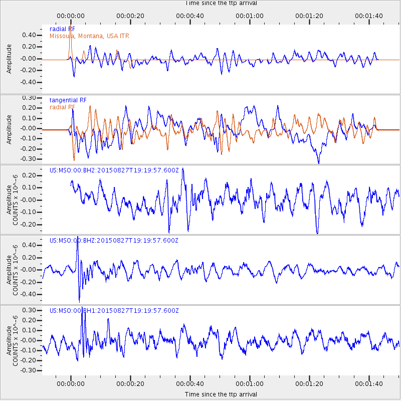
Signal To Noise
| Channel | StoN | STA | LTA |
| US:MSO:00:BHZ:20150827T19:19:57.600Z | 2.832112 | 2.1208345E-7 | 7.488526E-8 |
| US:MSO:00:BH1:20150827T19:19:57.600Z | 2.273687 | 1.2855611E-7 | 5.6540813E-8 |
| US:MSO:00:BH2:20150827T19:19:57.600Z | 1.4627242 | 1.05433124E-7 | 7.207998E-8 |
| Arrivals |
| Ps | |
| PpPs | |
| PsPs/PpSs | |


