You are here: Home > Network List > IU - Global Seismograph Network (GSN - IRIS/USGS) Stations List
> Station MAJO Matsushiro, Japan > Earthquake Result Viewer
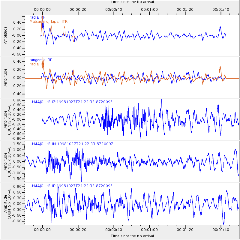
MAJO Matsushiro, Japan - Earthquake Result Viewer
*The percent match for this event was below the threshold and hence no stack was calculated.
| Earthquake location: |
Halmahera, Indonesia |
| Earthquake latitude/longitude: |
2.9/128.6 |
| Earthquake time(UTC): |
1998/10/27 (300) 21:16:21 GMT |
| Earthquake Depth: |
61 km |
| Earthquake Magnitude: |
5.9 MB, 5.9 UNKNOWN, 5.9 MW |
| Earthquake Catalog/Contributor: |
WHDF/NEIC |
|
| Network: |
IU Global Seismograph Network (GSN - IRIS/USGS) |
| Station: |
MAJO Matsushiro, Japan |
| Lat/Lon: |
36.54 N/138.21 E |
| Elevation: |
405 m |
|
| Distance: |
34.6 deg |
| Az: |
13.656 deg |
| Baz: |
197.025 deg |
| Ray Param: |
$rayparam |
*The percent match for this event was below the threshold and hence was not used in the summary stack. |
|
| Radial Match: |
70.09625 % |
| Radial Bump: |
400 |
| Transverse Match: |
61.17647 % |
| Transverse Bump: |
400 |
| SOD ConfigId: |
4480 |
| Insert Time: |
2010-03-04 16:12:08.260 +0000 |
| GWidth: |
2.5 |
| Max Bumps: |
400 |
| Tol: |
0.001 |
|
Signal To Noise
| Channel | StoN | STA | LTA |
| IU:MAJO: :BHN:19981027T21:22:33.872009Z | 2.3041482 | 4.769633E-7 | 2.07002E-7 |
| IU:MAJO: :BHE:19981027T21:22:33.872009Z | 1.8275913 | 3.4103957E-7 | 1.8660604E-7 |
| IU:MAJO: :BHZ:19981027T21:22:33.872009Z | 0.9387544 | 1.4821711E-7 | 1.57887E-7 |
| Arrivals |
| Ps | |
| PpPs | |
| PsPs/PpSs | |


