You are here: Home > Network List > IU - Global Seismograph Network (GSN - IRIS/USGS) Stations List
> Station MAJO Matsushiro, Japan > Earthquake Result Viewer
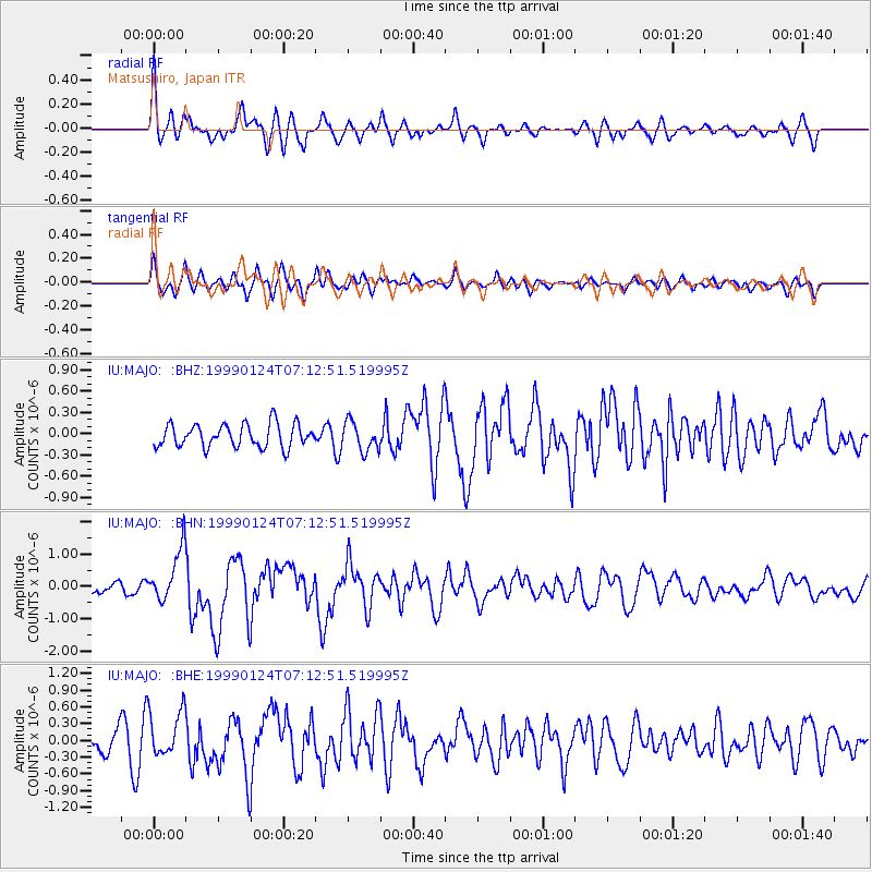
MAJO Matsushiro, Japan - Earthquake Result Viewer
*The percent match for this event was below the threshold and hence no stack was calculated.
| Earthquake location: |
Tonga Islands |
| Earthquake latitude/longitude: |
-21.1/-174.7 |
| Earthquake time(UTC): |
1999/01/24 (024) 07:01:58 GMT |
| Earthquake Depth: |
33 km |
| Earthquake Magnitude: |
5.7 MB, 5.9 MS, 6.1 MW, 6.0 MW |
| Earthquake Catalog/Contributor: |
WHDF/NEIC |
|
| Network: |
IU Global Seismograph Network (GSN - IRIS/USGS) |
| Station: |
MAJO Matsushiro, Japan |
| Lat/Lon: |
36.54 N/138.21 E |
| Elevation: |
405 m |
|
| Distance: |
72.6 deg |
| Az: |
321.79 deg |
| Baz: |
134.189 deg |
| Ray Param: |
$rayparam |
*The percent match for this event was below the threshold and hence was not used in the summary stack. |
|
| Radial Match: |
71.57972 % |
| Radial Bump: |
400 |
| Transverse Match: |
67.21361 % |
| Transverse Bump: |
400 |
| SOD ConfigId: |
4480 |
| Insert Time: |
2010-03-04 16:12:21.441 +0000 |
| GWidth: |
2.5 |
| Max Bumps: |
400 |
| Tol: |
0.001 |
|
Signal To Noise
| Channel | StoN | STA | LTA |
| IU:MAJO: :BHN:19990124T07:12:51.519995Z | 2.6046836 | 8.2063696E-7 | 3.1506204E-7 |
| IU:MAJO: :BHE:19990124T07:12:51.519995Z | 1.4801892 | 4.2007667E-7 | 2.837993E-7 |
| IU:MAJO: :BHZ:19990124T07:12:51.519995Z | 1.2600967 | 2.0400476E-7 | 1.6189614E-7 |
| Arrivals |
| Ps | |
| PpPs | |
| PsPs/PpSs | |


