You are here: Home > Network List > IU - Global Seismograph Network (GSN - IRIS/USGS) Stations List
> Station CCM Cathedral Cave, Missouri, USA > Earthquake Result Viewer
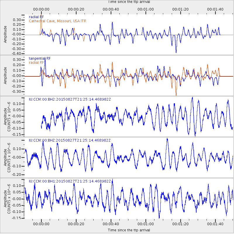
CCM Cathedral Cave, Missouri, USA - Earthquake Result Viewer
*The percent match for this event was below the threshold and hence no stack was calculated.
| Earthquake location: |
Hokkaido, Japan Region |
| Earthquake latitude/longitude: |
42.4/142.6 |
| Earthquake time(UTC): |
2015/08/27 (239) 21:13:13 GMT |
| Earthquake Depth: |
77 km |
| Earthquake Magnitude: |
4.5 mb |
| Earthquake Catalog/Contributor: |
ISC/ISC |
|
| Network: |
IU Global Seismograph Network (GSN - IRIS/USGS) |
| Station: |
CCM Cathedral Cave, Missouri, USA |
| Lat/Lon: |
38.06 N/91.24 W |
| Elevation: |
222 m |
|
| Distance: |
86.1 deg |
| Az: |
39.726 deg |
| Baz: |
323.164 deg |
| Ray Param: |
$rayparam |
*The percent match for this event was below the threshold and hence was not used in the summary stack. |
|
| Radial Match: |
51.602844 % |
| Radial Bump: |
400 |
| Transverse Match: |
53.803528 % |
| Transverse Bump: |
400 |
| SOD ConfigId: |
7422571 |
| Insert Time: |
2019-04-20 15:01:34.533 +0000 |
| GWidth: |
2.5 |
| Max Bumps: |
400 |
| Tol: |
0.001 |
|
Signal To Noise
| Channel | StoN | STA | LTA |
| IU:CCM:00:BHZ:20150827T21:25:14.468982Z | 1.6010395 | 9.341129E-8 | 5.834415E-8 |
| IU:CCM:00:BH1:20150827T21:25:14.468982Z | 0.762589 | 4.4936385E-8 | 5.8926087E-8 |
| IU:CCM:00:BH2:20150827T21:25:14.468982Z | 1.4442722 | 6.832092E-8 | 4.7304745E-8 |
| Arrivals |
| Ps | |
| PpPs | |
| PsPs/PpSs | |


