You are here: Home > Network List > ZQ15 - Taku Glacier Stations List
> Station GAGA Taku Glacier, Alaska, USA > Earthquake Result Viewer
GAGA Taku Glacier, Alaska, USA - Earthquake Result Viewer
| Earthquake location: |
Hokkaido, Japan Region |
| Earthquake latitude/longitude: |
42.4/142.6 |
| Earthquake time(UTC): |
2015/08/27 (239) 21:13:13 GMT |
| Earthquake Depth: |
77 km |
| Earthquake Magnitude: |
4.5 mb |
| Earthquake Catalog/Contributor: |
ISC/ISC |
|
| Network: |
ZQ Taku Glacier |
| Station: |
GAGA Taku Glacier, Alaska, USA |
| Lat/Lon: |
58.44 N/134.05 W |
| Elevation: |
258 m |
|
| Distance: |
51.9 deg |
| Az: |
41.583 deg |
| Baz: |
290.856 deg |
| Ray Param: |
0.06687068 |
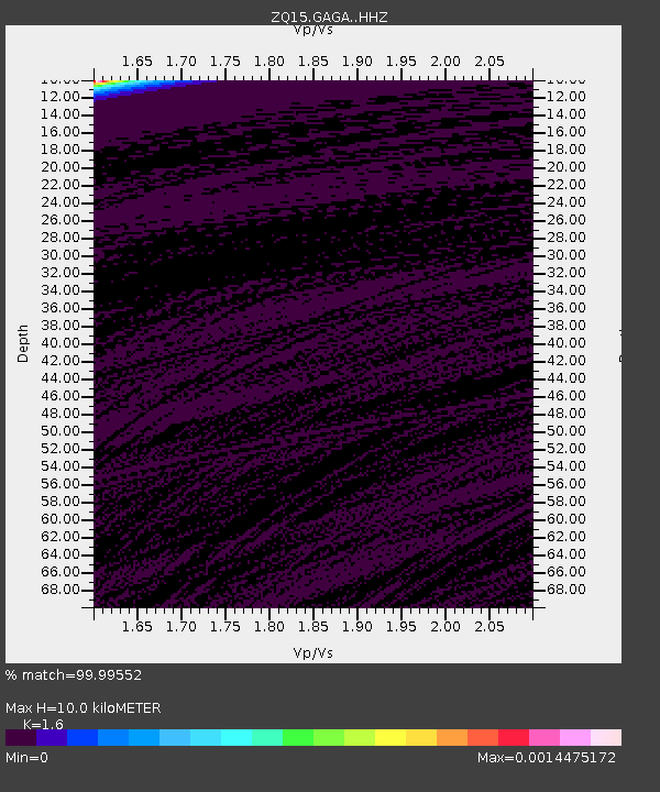
| Estimated Moho Depth: |
10.0 km |
| Estimated Crust Vp/Vs: |
1.60 |
| Assumed Crust Vp: |
6.566 km/s |
| Estimated Crust Vs: |
4.104 km/s |
| Estimated Crust Poisson's Ratio: |
0.18 |
|
| Radial Match: |
99.99552 % |
| Radial Bump: |
2 |
| Transverse Match: |
99.79506 % |
| Transverse Bump: |
18 |
| SOD ConfigId: |
7422571 |
| Insert Time: |
2019-04-20 15:06:52.350 +0000 |
| GWidth: |
2.5 |
| Max Bumps: |
400 |
| Tol: |
0.001 |
|

Signal To Noise
| Channel | StoN | STA | LTA |
| ZQ:GAGA: :HHZ:20150827T21:21:43.43999Z | 1.668036 | 2.543831E-6 | 1.5250456E-6 |
| ZQ:GAGA: :HH1:20150827T21:21:43.43999Z | 1.1926837 | 5.3889533E-8 | 4.5183423E-8 |
| ZQ:GAGA: :HH2:20150827T21:21:43.43999Z | 1.6599513 | 3.0870394E-6 | 1.8597169E-6 |
| Arrivals |
| Ps | 1.0 SECOND |
| PpPs | 3.7 SECOND |
| PsPs/PpSs | 4.7 SECOND |


