You are here: Home > Network List > TA - USArray Transportable Network (new EarthScope stations) Stations List
> Station L04D Klamath Falls, OR, USA > Earthquake Result Viewer
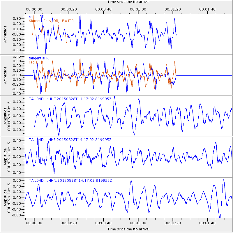
L04D Klamath Falls, OR, USA - Earthquake Result Viewer
*The percent match for this event was below the threshold and hence no stack was calculated.
| Earthquake location: |
Kermadec Islands Region |
| Earthquake latitude/longitude: |
-27.4/-176.2 |
| Earthquake time(UTC): |
2015/08/28 (240) 14:05:02 GMT |
| Earthquake Depth: |
49 km |
| Earthquake Magnitude: |
5.2 MW |
| Earthquake Catalog/Contributor: |
ISC/ISC |
|
| Network: |
TA USArray Transportable Network (new EarthScope stations) |
| Station: |
L04D Klamath Falls, OR, USA |
| Lat/Lon: |
42.22 N/122.30 W |
| Elevation: |
1437 m |
|
| Distance: |
85.3 deg |
| Az: |
37.051 deg |
| Baz: |
226.128 deg |
| Ray Param: |
$rayparam |
*The percent match for this event was below the threshold and hence was not used in the summary stack. |
|
| Radial Match: |
66.52206 % |
| Radial Bump: |
351 |
| Transverse Match: |
52.823444 % |
| Transverse Bump: |
285 |
| SOD ConfigId: |
7422571 |
| Insert Time: |
2019-04-20 15:11:41.780 +0000 |
| GWidth: |
2.5 |
| Max Bumps: |
400 |
| Tol: |
0.001 |
|
Signal To Noise
| Channel | StoN | STA | LTA |
| TA:L04D: :HHZ:20150828T14:17:02.819995Z | 1.2532258 | 1.9973659E-7 | 1.5937798E-7 |
| TA:L04D: :HHN:20150828T14:17:02.819995Z | 1.8431761 | 2.7244675E-7 | 1.4781375E-7 |
| TA:L04D: :HHE:20150828T14:17:02.819995Z | 0.775383 | 1.7360466E-7 | 2.2389537E-7 |
| Arrivals |
| Ps | |
| PpPs | |
| PsPs/PpSs | |


