You are here: Home > Network List > CI - Caltech Regional Seismic Network Stations List
> Station SWS Sam W. Stewart, Westmorland, CA, USA > Earthquake Result Viewer
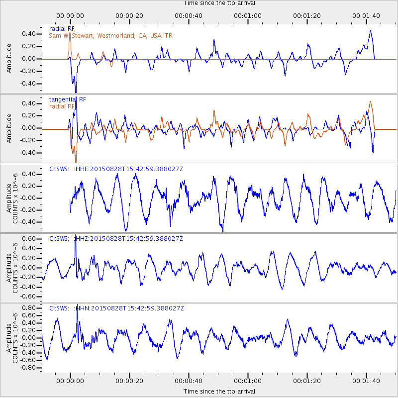
SWS Sam W. Stewart, Westmorland, CA, USA - Earthquake Result Viewer
*The percent match for this event was below the threshold and hence no stack was calculated.
| Earthquake location: |
Volcano Islands, Japan Region |
| Earthquake latitude/longitude: |
23.2/142.5 |
| Earthquake time(UTC): |
2015/08/28 (240) 15:30:59 GMT |
| Earthquake Depth: |
118 km |
| Earthquake Magnitude: |
5.3 MW |
| Earthquake Catalog/Contributor: |
ISC/ISC |
|
| Network: |
CI Caltech Regional Seismic Network |
| Station: |
SWS Sam W. Stewart, Westmorland, CA, USA |
| Lat/Lon: |
32.94 N/115.80 W |
| Elevation: |
140 m |
|
| Distance: |
86.9 deg |
| Az: |
55.54 deg |
| Baz: |
295.569 deg |
| Ray Param: |
$rayparam |
*The percent match for this event was below the threshold and hence was not used in the summary stack. |
|
| Radial Match: |
46.8205 % |
| Radial Bump: |
400 |
| Transverse Match: |
47.32592 % |
| Transverse Bump: |
400 |
| SOD ConfigId: |
7422571 |
| Insert Time: |
2019-04-20 15:15:34.560 +0000 |
| GWidth: |
2.5 |
| Max Bumps: |
400 |
| Tol: |
0.001 |
|
Signal To Noise
| Channel | StoN | STA | LTA |
| CI:SWS: :HHZ:20150828T15:42:59.388027Z | 1.8347071 | 1.9059505E-7 | 1.0388308E-7 |
| CI:SWS: :HHN:20150828T15:42:59.388027Z | 1.2794769 | 2.6810883E-7 | 2.0954568E-7 |
| CI:SWS: :HHE:20150828T15:42:59.388027Z | 0.75786525 | 1.7936402E-7 | 2.3667008E-7 |
| Arrivals |
| Ps | |
| PpPs | |
| PsPs/PpSs | |


