You are here: Home > Network List > US - United States National Seismic Network Stations List
> Station HAWA Hanford, Washington, USA > Earthquake Result Viewer
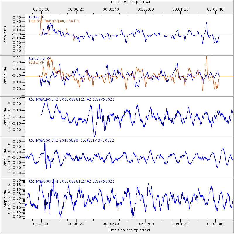
HAWA Hanford, Washington, USA - Earthquake Result Viewer
*The percent match for this event was below the threshold and hence no stack was calculated.
| Earthquake location: |
Volcano Islands, Japan Region |
| Earthquake latitude/longitude: |
23.2/142.5 |
| Earthquake time(UTC): |
2015/08/28 (240) 15:30:59 GMT |
| Earthquake Depth: |
118 km |
| Earthquake Magnitude: |
5.3 MW |
| Earthquake Catalog/Contributor: |
ISC/ISC |
|
| Network: |
US United States National Seismic Network |
| Station: |
HAWA Hanford, Washington, USA |
| Lat/Lon: |
46.39 N/119.53 W |
| Elevation: |
364 m |
|
| Distance: |
78.8 deg |
| Az: |
44.323 deg |
| Baz: |
291.769 deg |
| Ray Param: |
$rayparam |
*The percent match for this event was below the threshold and hence was not used in the summary stack. |
|
| Radial Match: |
56.10946 % |
| Radial Bump: |
400 |
| Transverse Match: |
64.20979 % |
| Transverse Bump: |
400 |
| SOD ConfigId: |
7422571 |
| Insert Time: |
2019-04-20 15:18:56.638 +0000 |
| GWidth: |
2.5 |
| Max Bumps: |
400 |
| Tol: |
0.001 |
|
Signal To Noise
| Channel | StoN | STA | LTA |
| US:HAWA:00:BHZ:20150828T15:42:17.975002Z | 2.225383 | 2.1473842E-7 | 9.6495036E-8 |
| US:HAWA:00:BH1:20150828T15:42:17.975002Z | 0.92785054 | 9.5652574E-8 | 1.0309049E-7 |
| US:HAWA:00:BH2:20150828T15:42:17.975002Z | 1.7169564 | 1.6651776E-7 | 9.6984266E-8 |
| Arrivals |
| Ps | |
| PpPs | |
| PsPs/PpSs | |


