You are here: Home > Network List > IU - Global Seismograph Network (GSN - IRIS/USGS) Stations List
> Station MAKZ Makanchi, Kazakhstan > Earthquake Result Viewer
MAKZ Makanchi, Kazakhstan - Earthquake Result Viewer
| Earthquake location: |
New Britain Region, P.N.G. |
| Earthquake latitude/longitude: |
-5.2/151.8 |
| Earthquake time(UTC): |
2015/05/01 (121) 08:06:05 GMT |
| Earthquake Depth: |
54 km |
| Earthquake Magnitude: |
7.1 MO |
| Earthquake Catalog/Contributor: |
NEIC PDE/NEIC ALERT |
|
| Network: |
IU Global Seismograph Network (GSN - IRIS/USGS) |
| Station: |
MAKZ Makanchi, Kazakhstan |
| Lat/Lon: |
46.81 N/81.98 E |
| Elevation: |
600 m |
|
| Distance: |
80.2 deg |
| Az: |
319.14 deg |
| Baz: |
108.46 deg |
| Ray Param: |
0.0483559 |
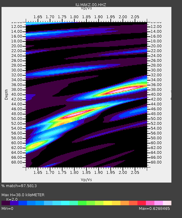
| Estimated Moho Depth: |
38.0 km |
| Estimated Crust Vp/Vs: |
2.00 |
| Assumed Crust Vp: |
6.571 km/s |
| Estimated Crust Vs: |
3.285 km/s |
| Estimated Crust Poisson's Ratio: |
0.33 |
|
| Radial Match: |
97.5813 % |
| Radial Bump: |
292 |
| Transverse Match: |
89.963936 % |
| Transverse Bump: |
400 |
| SOD ConfigId: |
872571 |
| Insert Time: |
2015-05-15 14:09:25.677 +0000 |
| GWidth: |
2.5 |
| Max Bumps: |
400 |
| Tol: |
0.001 |
|
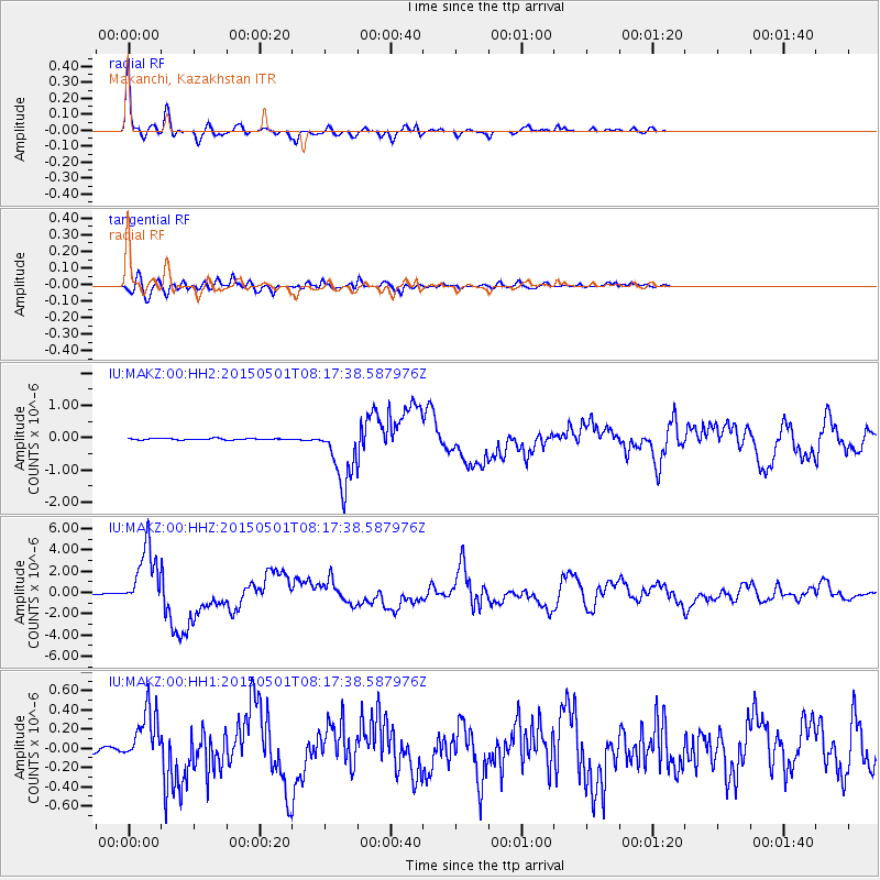
Signal To Noise
| Channel | StoN | STA | LTA |
| IU:MAKZ:00:HHZ:20150501T08:17:38.587976Z | 88.574554 | 2.917915E-6 | 3.294304E-8 |
| IU:MAKZ:00:HH1:20150501T08:17:38.587976Z | 11.554552 | 2.773542E-7 | 2.4003889E-8 |
| IU:MAKZ:00:HH2:20150501T08:17:38.587976Z | 48.70845 | 9.762863E-7 | 2.0043467E-8 |
| Arrivals |
| Ps | 5.9 SECOND |
| PpPs | 17 SECOND |
| PsPs/PpSs | 23 SECOND |


