You are here: Home > Network List > UW - Pacific Northwest Regional Seismic Network Stations List
> Station UMAT Pilot Rock, OR, USA > Earthquake Result Viewer
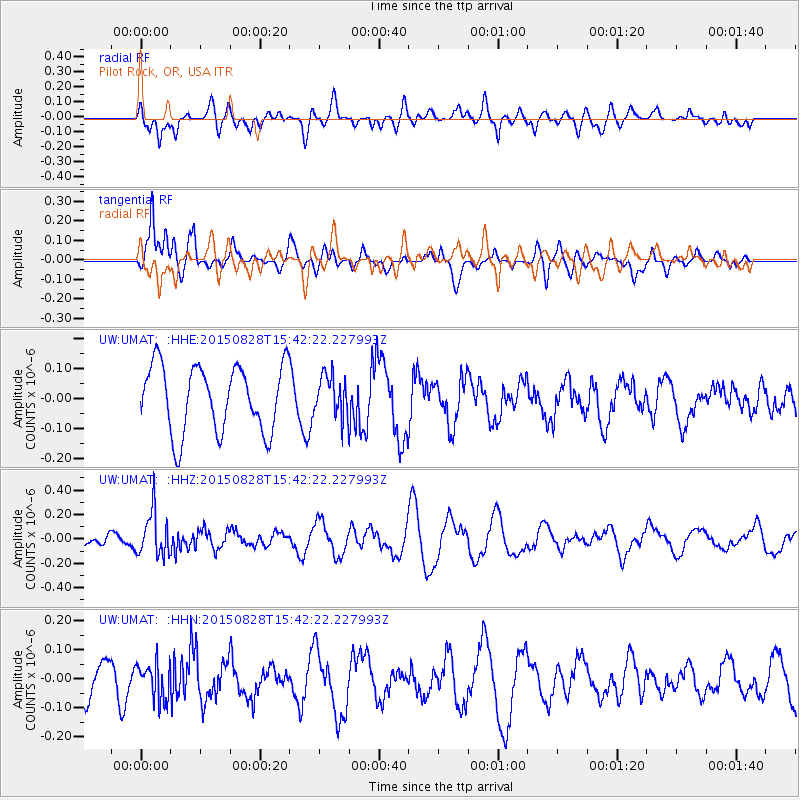
UMAT Pilot Rock, OR, USA - Earthquake Result Viewer
*The percent match for this event was below the threshold and hence no stack was calculated.
| Earthquake location: |
Volcano Islands, Japan Region |
| Earthquake latitude/longitude: |
23.2/142.5 |
| Earthquake time(UTC): |
2015/08/28 (240) 15:30:59 GMT |
| Earthquake Depth: |
118 km |
| Earthquake Magnitude: |
5.3 MW |
| Earthquake Catalog/Contributor: |
ISC/ISC |
|
| Network: |
UW Pacific Northwest Regional Seismic Network |
| Station: |
UMAT Pilot Rock, OR, USA |
| Lat/Lon: |
45.29 N/118.96 W |
| Elevation: |
1318 m |
|
| Distance: |
79.6 deg |
| Az: |
45.209 deg |
| Baz: |
292.345 deg |
| Ray Param: |
$rayparam |
*The percent match for this event was below the threshold and hence was not used in the summary stack. |
|
| Radial Match: |
35.766586 % |
| Radial Bump: |
400 |
| Transverse Match: |
58.481895 % |
| Transverse Bump: |
400 |
| SOD ConfigId: |
7422571 |
| Insert Time: |
2019-04-20 15:19:32.805 +0000 |
| GWidth: |
2.5 |
| Max Bumps: |
400 |
| Tol: |
0.001 |
|
Signal To Noise
| Channel | StoN | STA | LTA |
| UW:UMAT: :HHZ:20150828T15:42:22.227993Z | 3.2229843 | 1.80807E-7 | 5.609925E-8 |
| UW:UMAT: :HHN:20150828T15:42:22.227993Z | 0.9875904 | 6.257303E-8 | 6.3359295E-8 |
| UW:UMAT: :HHE:20150828T15:42:22.227993Z | 0.6048623 | 6.692124E-8 | 1.1063881E-7 |
| Arrivals |
| Ps | |
| PpPs | |
| PsPs/PpSs | |


