You are here: Home > Network List > TA - USArray Transportable Network (new EarthScope stations) Stations List
> Station J01E Myrtle Point, OR, USA > Earthquake Result Viewer
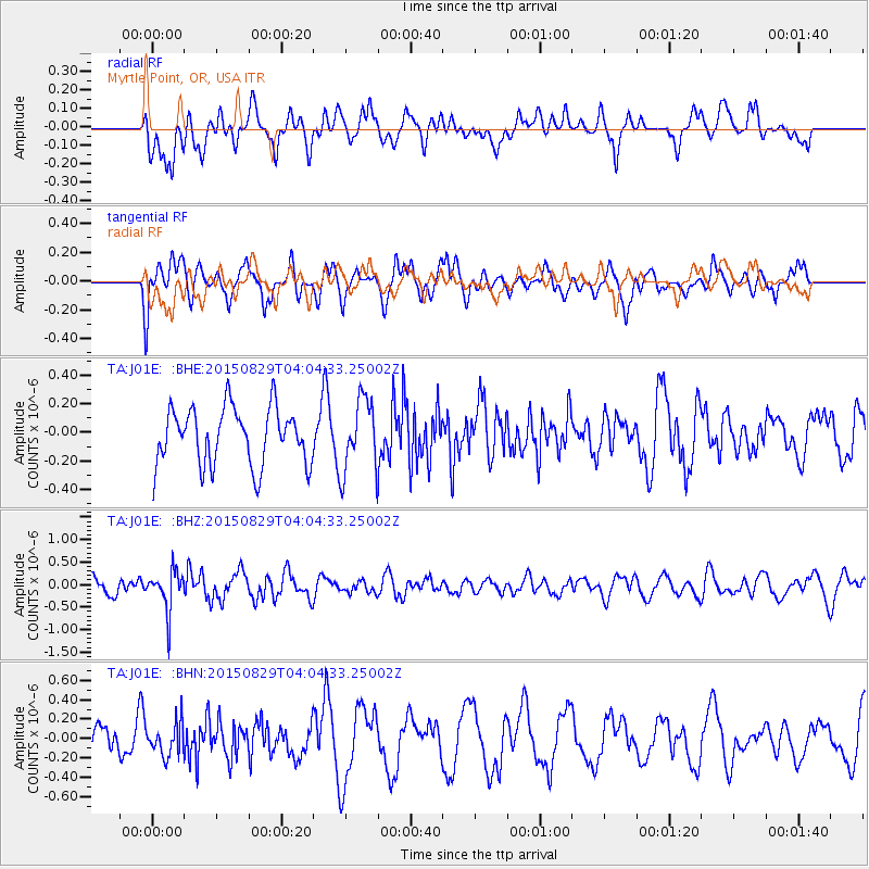
J01E Myrtle Point, OR, USA - Earthquake Result Viewer
*The percent match for this event was below the threshold and hence no stack was calculated.
| Earthquake location: |
Mariana Islands |
| Earthquake latitude/longitude: |
19.1/145.7 |
| Earthquake time(UTC): |
2015/08/29 (241) 03:53:23 GMT |
| Earthquake Depth: |
124 km |
| Earthquake Magnitude: |
5.5 MB |
| Earthquake Catalog/Contributor: |
NEIC PDE/NEIC COMCAT |
|
| Network: |
TA USArray Transportable Network (new EarthScope stations) |
| Station: |
J01E Myrtle Point, OR, USA |
| Lat/Lon: |
43.16 N/123.93 W |
| Elevation: |
128 m |
|
| Distance: |
77.4 deg |
| Az: |
48.558 deg |
| Baz: |
284.424 deg |
| Ray Param: |
$rayparam |
*The percent match for this event was below the threshold and hence was not used in the summary stack. |
|
| Radial Match: |
55.532425 % |
| Radial Bump: |
400 |
| Transverse Match: |
69.75114 % |
| Transverse Bump: |
400 |
| SOD ConfigId: |
7422571 |
| Insert Time: |
2019-04-20 15:25:42.806 +0000 |
| GWidth: |
2.5 |
| Max Bumps: |
400 |
| Tol: |
0.001 |
|
Signal To Noise
| Channel | StoN | STA | LTA |
| TA:J01E: :BHZ:20150829T04:04:33.25002Z | 2.6008692 | 4.5421325E-7 | 1.7463901E-7 |
| TA:J01E: :BHN:20150829T04:04:33.25002Z | 0.9143056 | 1.730443E-7 | 1.8926308E-7 |
| TA:J01E: :BHE:20150829T04:04:33.25002Z | 1.1600316 | 2.2075157E-7 | 1.9029791E-7 |
| Arrivals |
| Ps | |
| PpPs | |
| PsPs/PpSs | |


